$5 - $10 Geography Worksheets (by price, high to low)

Geography & Map Types & Skills & Activities 4th 5th 6th grades Social Studies
By The Magical Avocado
Teaching Geography? This bundle has everything you need to teach different map types, map skills, latitude and longitude, and more! This bundle includes a combination of ready-to-print reading and response, activity sheets, maze puzzles, cut-and-paste activities, writing prompts, and assessments. Perfect for upper elementary (4th, 5th, and 6th grade), this complete bundle is great for substitute work, centers, the beginning of the year, introduction and review of geography, enrichment, home school assignments, and centers!
Specifically, this bundle includes:
- 8 read and respond
- 6 Maze Activities
- 4 Cut and Paste
- 4 skills practice pages
- 2 USA Maps for practice
- 2 writing pages
- 1 short answer quiz
- 1 matching quiz
- 1 mini project
- 3 Teaching Guides
This bundle covers the following concepts:
- Absolute Location
- Cardinal Directions
- Cartographer
- Compass Rose
- Coordinates
- Equator
- Intermediate Directions
- Latitude
- Legend
- Longitude
- Prime Meridian
- Relative Location
- Scale
- Symbols
and the following map types
- choropleth
- general reference map
- globe
- physical map
- political map
- special purpose map
- topographical map
- weather map
By Creative Soul Printables
Explore the diverse and fascinating United States of America with our 50 States Notebook Pages. This educational and engaging product is designed to help students and travelers of all ages learn more about each of the 50 states that make up this vast and culturally rich nation. Whether you're a student researching state history, a traveler planning a road trip, or an educator looking for engaging teaching resources, these notebook pages are the perfect companion.
Key Features:
- Comprehensive Coverage: Each state has its dedicated page, providing an in-depth overview of its history.
- Beautifully Illustrated: Vibrant and detailed illustrations bring each state to life, making the learning experience more enjoyable and visually appealing.
- Customizable Format: The notebook pages are thoughtfully designed to be easily printable and fit into standard notebooks or binders. You can create your personalized 50 States Notebook by arranging the pages in any order that suits your needs.
- State Flags and Symbols: Learn about the unique state flags, official seals, and other symbols that represent the identity and heritage of each state.
- Great for All Ages: Whether you're a curious youngster or an adult seeking to expand your knowledge, these notebook pages are suitable for learners of all ages and backgrounds.
- Educational Tool: Ideal for homeschooling, classroom teaching, or self-study, the 50 States Notebook Pages are a valuable resource for educators, parents, and students alike.
Uses:
- Education: Perfect for integrating state-specific knowledge into social studies, geography, or history lessons.
- Travel Planning: Plan your dream road trip across the United States, knowing more about each state you'll visit.
*************************************************************
What is included:
Map to write in abbreviations of states to know locations
Notebook Pages for all 50 States
Images for state trees, seals, flags, flowers, birds and flowers
*************************************************************
Other Related Products that May Interest You:
⭐ 50 States Abbreviations BINGO
⭐ 50 States BINGO
**************************************************************
How to get TeachShare credit to use on future purchases:
Please go to your “My Purchases” page (you may need to login). Beside each purchase you'll see a Provide Feedback button. Simply click it and you will be taken to a page where you can give a quick rating and leave a short comment for the product.
Each time you give feedback, TeachShare gives you feedback credits that you use to lower the cost of your future purchases. I value your feedback greatly as it helps me determine which products are most valuable for your classroom so I can create more for you.
Be the first to know about my new discounts, freebies and product launches: Check out my store to know first! **************************************************************

Geography - ALL CONTINENTS BUNDLE - 20 Atlas / Google Maps Questions
By Quick Assignment Central
Includes an individual assignment for each continent. 7 Individual assignments.
Unlock an exciting geography quiz that brings the continent to life! This set features 20 thoughtfully designed questions covering landforms, countries, capitals, and more.
Students will need an atlas or Google Maps to answer the questions, making it a fun and interactive learning experience.
Includes a complete answer key for easy review.
Perfect for sparking curiosity and building knowledge!
Don’t forget to explore my store for more engaging educational resources!
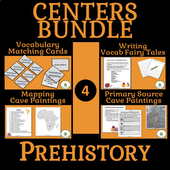
Prehistory Centers BUNDLE- Vocabulary, Writing, Maps, Primary Sources
By The Magical Avocado
Bring Prehistory to life in your class with this centers bundle! Have students practice vocabulary recognition with a ready to print and cut matching game, integrate ELA in a prehistory story assignment, work on geography skills while mapping cave paintings online, and use the tools of historians and anthropologists while analyzing primary sources.
Centers are a great way to keep students engaged while introducing a variety of information and skills.
In addition to the four activities included, this bundle introduces a Prehistory Centers Teaching Guide which includes:
- An overview of the centers as activities working together
- A planning guide describing the skills, knowledge, materials, and grading for each center
- A plan for introducing the centers along with directions for the INCLUDED fully editable centers introduction powerpoint slide
- A guide on timing of centers based on class schedules
- Center Rotation Suggestions for using four or five centers
- Printable Title Pages for the Centers
****** Also included is a list of 15 Suggested Reflection Questions to use as closure for the centers

World Map Worksheets | 7 Continents and 5 Oceans Blank Map Skills & Activities
By Innovative Classroom Ideas
Kids enjoy studying about the world in which they live! With the help of these entertaining printable Continents and Oceans Worksheets, they will love learning about the seven continents and the corresponding geography. For students in kindergarten, first grade, second grade, third grade, fourth grade, fifth grade, and sixth grade, these worksheets offer a fun and interactive way to explore our planet. Through engaging activities like coloring, labeling, and matching, students will develop a solid understanding of the continents and oceans while sparking their curiosity about the diverse cultures and natural wonders of the world. Let’s embark on a global adventure together!
By completing the various activities, children will enhance their map skills, vocabulary, and critical thinking abilities. These printable resources are perfect for homeschooling, classroom use, or simply as a fun activity to do at home.
These no prep worksheets offer a wide range of activities to keep young learners engaged. From simple tracing and coloring to more challenging puzzles and word searches, there’s something for everyone. With these worksheets, learning about the continents and oceans is both educational and enjoyable.
✅ Save more than 50% when you get a bundle ✅
This bundle contains the following resources:
⭐ Blank World Map with Countries | 7 Continents and 5 Oceans | United States Map
These printable maps will be useful whether you are studying geography, world history, countries around the world, or you are just trying to show your kids the route you are taking on your next vacation! For kids learning about states, we’ve included a printable map of the world, as well as maps of North and South America, Europe, Asia, Australia, Africa, and Antarctica. Furthermore, the world map printable set comprises labeled and blank options for printing. To print the printable map pdf file simply download this ressource and use it for students in pre-kindergarten, first grade, second grade, third grade, fourth grade, fifth grade, sixth grade, seventh grade, junior high, and even high school.
The blank world map is particularly useful for providing a bird’s eye perspective of the globe, oceans, continents, and major nations. It also helps locate me on the map with children of various ages.
That ressource countains:
- Blank World Map (with /without country names)
- North America Map (with / without country names)
- South America Map (with / without country names)
- Australia Map (with / without country names)
- Asia Map (with / without country names)
- Europe Map (with / without country names)
- Antarctica Map (with / without country names)
- Africa Map (with / without country names)
- United States Map (with / without country names)
⭐ World Map with Countries Worksheets | 7 Continents and 5 Oceans Blank Map
Kids enjoy studying the world they live in! They will enjoy learning about the seven continents and the corresponding geography with these fun and printable Continents Worksheets. For kindergarteners, first graders, second graders, third graders, fourth graders, and fifth graders, use these continents and oceans worksheets. You may start playing and learning as soon as you print the continents and oceans worksheet PDF.
These 7 continents and 5 oceans worksheets are perfect for parents, teachers, and homeschoolers who want to assist their kids learn about the globe we live in and improve their science skills. For kindergarteners, first-graders, second-graders, third-graders, fourth-graders, and fifth-graders, this pack is ideal. Use these no prep 7 Continents worksheets for science centers, additional practice, at home or at school, or as a component of a continent study. Children will learn about the seven continents that today make up the world in which we live with this bundle. Answers are provided and this pack comes mainly in black and white with a few color pages thrown in.
There are lots of activities in this pack:
- Continent poster in color
- Color in the continents on the world map following the key
- Cut out and paste the labels onto the continents
- Write the names of the seven continents next to the corresponding number
- Color in the continents using the key
- Unscramble the names of the continents
- One page for each of the seven continents with facts that include the hemisphere the continent is in, the oceans that surround it, and the amount of countries that are in that continent
- Write the names of the continents in alphabetical order
- Continent word search
⭐ Continents and Oceans Worksheets | Blank World Map with Countries | Map Skills
This set of printable pages on the seven continents is a fantastic way to practice geography. With the help of this continents and oceans worksheet pdf, students will enjoy learning about the seven major continents. Use these maps with kindergarten, first, second, third, fourth, fifth, and sixth grade elementary students as part of a social studies subject, as a stand-alone review, or as additional practice.
These 7 Continents and 5 Oceans worksheets will be a hit with your pupils as they practice labeling the different continents and discover fascinating facts about each one. You only need to print the continents and oceans worksheet to begin teaching kindergarteners, first-graders, second-graders, third-graders, fourth-graders, fifth-graders, and sixth-graders. This no-prep geography lesson will help children learn about Asia, Africa, Australia, North America, Antarctica, South America, and Europe. It is perfect for parents, teachers, and homeschoolers. Now that you have these continents worksheets, you can start learning! The answer key is provided!!
⭐ World Map Skills Worksheets | 7 Continents and 5 Oceans | Geography Activities
This printable page pack featuring the seven continents is an excellent tool for honing geography skills. These continents and oceans worksheet pdf will make learning about the seven major continents enjoyable for students. Utilize these no prep worksheets with kindergarten, first, second, third, fourth, fifth, and even sixth graders! With vibrant colors and engaging activities, these worksheets turn geography into an adventure. Children will love coloring the continents, labeling oceans, and matching animals to their habitats. Perfect for homeschooling, classroom use, or simply for curious young minds. Let’s explore the world together!
From basic map skills to understanding cultural differences, these no prep continents and oceans worksheets provide a solid foundation for future learning. Download your set today and start your global exploration! Students will love searching for hidden objects, solving puzzles, and creating their own maps. These engaging activities will spark their curiosity and inspire a lifelong love of geography. Plus, they’re a great way to reinforce essential skills like following directions and problem-solving.
>>>> ⭐ More Similar Activities ⭐ <<<<<
We adore FEEDBACK! You also obtain CREDITS! :
- Access your TeachShare account by logging in.
- Select "My TeachShare" from the drop-down menu.
- Click on "My Purchases."
- Select ratings and provide feedback.
Terms of Use: By purchasing and/or downloading this electronic file, you are allowed to use the product for personal use as you like, but you are not allowed to resell or redistribute.
Follow my store and get all the newest product updates and freebies by clicking the green star ★ above.
♥ Search Key Terms: World map, world maps, world, world geography, map of the world, world map is wrong, world map for kids, world facts, map of world, #world, new world map, free world map, accurate world map, world puzzle, world oceans, fixing the world map, World map, world,blank map, how to draw world map easily, world map drawing, how to draw world map, world maps,European school draw world map, world map drawing easy, world map draw kaise kare, world map flat, world map draw in ias mains exam, how to draw a world map in easy steps, world map quiz, easy world map, how to draw world map in examination, how to dry world map in upsc mains exam, Continents and oceans, the continents and oceans of the world worksheet, continents and oceans for kids, continents and oceans for kids, continents and oceans workbook, continents and oceans free course, continents and oceans printables, homeschool continents and oceans, classroom continents and oceans resources, homeschool continents and oceans resources, oceans and continents, Map skills, map skills for kids, map skill, skills,map symbols,, map,map skills tutorial, map skills geography,map skill of India, reading a map, map reading skills, map skill for third grade, map scales, how to teach map skills to students, how to teach map skills to students, mapping skills, map skill of ch 3 drainage class 9 geography, navigational skills., #maps, reading a map for kids, map legends, hiking skills, how to make a map, how to read a map
Emergency Spanish Sub Plans Mexico
By ARIANA PEREZ
Are you a Spanish teacher in a hurry? This Emergency Spanish Sub Plans Mexico Edition book has no-prep activities suitable for all levels of Spanish, includes :
- A Spanish Version of a Map Activity
- An English Version of this same activity
- 5 Spanish Readings
- 2 coloring pages
- Mexico Map Labeling Activity
- 3 Fact Sheet Worksheets for lower levels
Whether you're a full-time teacher looking for a comprehensive sub plan or a substitute teacher in need of emergency lesson plans, this book is an excellent resource that will help your students stay on track and continue their language learning journey.
More resources:
Speech Therapy Pack
Speaking Game to practice for the AP Spanish Exam
Workbook for AP Spanish Literature
Games/Activities for the Spanish Classroom
Map Google Drive Activity for Any Language
Stay connected:
→ My Blog
Want to be the first to know about the latest resources and special promotions? Follow me on TeachShare HERE!
Terms of Use
THESPANGLISHMOM™️. By purchasing and/or downloading this electronic file, you agree to the following terms. For personal use/single classroom use only. No part of this document may be distributed, posted on the internet, copied, edited, or resold. ALL contents of this document are under copyright protection including all content, text, fonts, and graphics, Thank you for respecting my hard word as well as the hard work of the artists whose work helped create this product.
To purchase additional licenses select to purchased additional licenses at checkout or go to “my purchases”, select the item, and click “buy additional licenses”. Did you know there are TeachShare School Accounts? Tell your administrator and ask if your school will purchase this for your classroom.
Geography | What Causes Hunger lesson activity worksheet
By Yugen Learning
In this no prep lesson, students learn to analyse and interpret the information on what causes Hunger's part of your Geography program.
This comprehensive and interactive lesson plan, entitled "What Causes Hunger?", guides students through a thoughtful exploration of the various factors contributing to global hunger.
It engages students in a detailed understanding of the cycle of poverty, lack of agricultural investment, effects of climate and weather, war and displacement, unstable markets, and food wastage, and how each of these components plays a role in the prevalence of hunger.
Resources included:
- Guided instruction and links to external resources, such as the World Food Programme video "$1 a day," to provide a broader context and real-life representation of the issues.
- Individual activities and reflection prompts that encourage students to form their own conclusions, as well as express and validate their ideas.
- Discussion questions, both true or false and open-ended, to stimulate critical thinking and facilitate lively, thoughtful conversation in the classroom.
- A concluding reflection, challenging students to make connections between hunger, poverty, and economic development.
This comprehensive lesson is designed to cultivate an empathetic, global perspective among students and inspire them to think critically about worldwide issues like hunger. Suitable for Social Studies, Geography, Economics, and Global Studies courses for middle and high school levels.
Aligned with Common Core Standards, this lesson also encourages students to apply their knowledge, analyze various viewpoints, and build strong argumentation skills. Download now to open your classroom to a comprehensive and compassionate study of world hunger.
Australian Geography Curriculum link:
Challenges to food production, including land and water degradation, shortage of fresh water, competing land uses, and climate change, for Australia and other areas of the world (ACHGK063)
Students will begin to see that certain features and shapes are often associated with particular population structures e.g. a wide base indicates a high birth rate, a narrow apex often indicates a high death rate, etc.
Within the lesson, students will be expected to apply this new knowledge and understanding by analyzing and interpreting a population pyramid from a range of countries.
Students also learn how variations in shape and size also relate to the dependency ratio (the amount of the population that is dependent on the working population) of a particular country. Students practice calculating and interpreting dependency ratio through a number of examples.
These slides can also be printed and displayed within the classroom or given to students as review notes.
Enjoy this resource! Don't forget to follow my store for more awesome products and rate this product for your TeachShare credits :)
SUBSCRIBE NOW to my list for a free copy of the eBook "ChatGPT for history Teachers" and a Story, Source, Scholarships resources to see how well they work in your classroom.
Request a resource:
If you like my resources but I have uploaded a particular one you would love, please email me and tell me what you would like me to deign:
kane@yugenlearning,com or Subscribe to Our Enlightening Educators’ Mailing List Now!
People that have purchased this resource have also purchased -
More great curriculum resources
✅ ➡ USA History
✅ ➡ USA History Unit One
✅ ➡ USA History Unit Two
✅ ➡ USA History Unit Three
✅ ➡ USA History Unit Four
✅ ➡ USA History Unit Five
✅ ➡ American Revolution
✅ ➡ ⚔ US Civil War
✅ ➡ Medieval History
✅ ➡ World War One
✅ ➡ Nazi Germany
✅ ➡ ✈ World War Two
✅ ➡ ☭️ Cold War
✅ ➡ Australian History
✅ ➡ ⚙ Industrial Revolution
and
Subscribe to my Teaching Newsletter
Follow us!!!!!
https://www.instagram.com/yugenlearning/
https://www.pinterest.com.au/yugenlearning/
TeachShare Store
https://www.TeachShare.com/Store/Yugen-Learning
Please share feedback to help me improve my resources for you.
World Geography - Geographical Scavenger Hunt Printable and Digital activity
By Yugen Learning
If you are looking for a creative and no-prep, self contained for emergency sub resource for middle of high school to teach about world geography Map Labelling Challenge. This printable and digital activity works as bellringer or ongoing task to teach or assess your students about geographical knowledge locations from oceans to countries for your Geography program.
In this no prep lesson, Geographical Scavenger Hunt to identify continents, oceans, seas, mountains ranges, bays, gulfs, rivers, countries, latitude & longitude lines on world map and is suitable for students for a back to school tasks to to test and revise their geographical information.
Geographical Map Labelling Challenge
Objective: To enhance students' knowledge of the world's geography by identifying and naming various geographical features using a numbered world map.
Task:
Using the numbers as references, students must identify and label the following:
- Continents: All the continents marked on the map.
- Oceans: All the major oceans indicated.
- Rivers: Major rivers that are numbered.
- Mountain Ranges: Identify the mountain ranges marked on the map.
- Bays and Gulfs: Label the bays and gulfs indicated.
- Lines of Latitude & Longitude: Identify and label the major lines of latitude (e.g., Equator, Tropics) and longitude (e.g., Prime Meridian).
- Countries: Label as many countries as possible that are numbered on the map.
Resources includes
- Digital worksheet
- Printable worksheet
- Marking key
I like starting with them working singly to answer as many as they can, then moving on working in groups. Finally using an atlas to complete the sheet. Or you can use it as an ongoing start/end of lesson task for the first/last 5 minutes. Student love the challenge.
Extension Activities:
- Ask students to research and write a brief description of a geographical feature they found challenging to identify.
- Organize a group discussion where students can share interesting facts about a particular country or geographical feature they labeled.
- Encourage students to create a visual presentation or poster showcasing a specific continent and its unique geographical features.
This task promotes active learning as students engage with the map, utilize their geographical knowledge, and collaborate with peers to identify and label the world's major features.
Common Core
RH.6-8.7 Integrate visual information (e.g., in charts, graphs, photographs, videos, or maps) with other information in print and digital texts.
Australian Geography Curriculum link:
Challenges to food production, including land and water degradation, shortage of fresh water, competing land uses, and climate change, for Australia and other areas of the world (ACHGK063)
Upon completing your purchase, you will click on the green button that says Add to Google Drive. Then, you will be able to find this resource in the TeachShare Purchases folder of your Google Drive account! If you have any technical issues, reach out to us at yugenlearning@gmail.com or contact TeachShare.
Enjoy this resource! Don't forget to follow my store for more awesome products and rate this product for your TeachShare credits :)
People that have purchased this resource have also purchased -
Curriculum resources can be accessed here
Geography
$ Economics
Medieval History
✅ ➡ World War One
✅ ➡ Nazi Germany
✅ ➡ ✈ World War Two
✅ ➡ v ☭️ Cold War
✅ ➡ Australian History
✅ ➡ ⚙ Industrial Revolution
✅ ➡ USA History
✅ ➡ American Revolution
✅ ➡ ⚔ US Civil War
✊ USA Civil Rights
and
Subscribe to my Teaching Newsletter for a History Teachers AI guide and one of my best selling history resources.
Follow us!!!!!
https://www.instagram.com/yugenlearning/
https://www.pinterest.com.au/yugenlearning/
TeachShare Store
https://www.TeachShare.com/Store/Yugen-Learning
Please share feedback to help me improve my resources for you.
Geography - Hemispheres, Continents and Lines of Latitude Worksheet
By Yugen Learning
In this no prep lesson for you or an emergency sub in your Geography program, students will embark on a geographical journey to explore the intricate details of our world's layout. They will be provided with a detailed map, which will serve as their canvas to mark and identify the lines of latitude, distinguish between the different hemispheres, and pinpoint the continents. As they navigate through the map, students will also encounter a series of questions designed to test their understanding and observation skills.
Task:
Using the numbers as references, students must identify and label the following:
- Continents
- Oceans
- Continents
- Hemispheres
- Lines of Latitude
Develop mate reading skills and visual recombination skills
Resources:
A3 size sheet
Marking key
Enjoy this resource! Don't forget to follow my store for more awesome products and rate this product for your TeachShare credits :)
People that have purchased this resource have also purchased -
Geography | What Causes Hunger lesson activity
Geography | Analysing and Interpreting Population Pyramids
Geography | Geographical Scavenger Hunt
Please leave a review.
World Geography - Geographical Scavenger Hunt Printable and Digital activity
By Yugen Learning
If you are looking for a creative and no-prep, self contained for emergency sub resource for middle of high school to teach about world geography Map Labelling Challenge. This printable and digital activity works as bellringer or ongoing task to teach or assess your students about geographical knowledge locations from oceans to countries for your Geography program.
In this no prep lesson, Geographical Scavenger Hunt to identify continents, oceans, seas, mountains ranges, bays, gulfs, rivers, countries, latitude & longitude lines on world map and is suitable for students for a back to school tasks to to test and revise their geographical information.
Geographical Map Labelling Challenge
Objective: To enhance students' knowledge of the world's geography by identifying and naming various geographical features using a numbered world map.
Task:
Using the numbers as references, students must identify and label the following:
- Continents: All the continents marked on the map.
- Oceans: All the major oceans indicated.
- Rivers: Major rivers that are numbered.
- Mountain Ranges: Identify the mountain ranges marked on the map.
- Bays and Gulfs: Label the bays and gulfs indicated.
- Lines of Latitude & Longitude: Identify and label the major lines of latitude (e.g., Equator, Tropics) and longitude (e.g., Prime Meridian).
- Countries: Label as many countries as possible that are numbered on the map.
Resources includes
- Digital worksheet
- Printable worksheet
- Marking key
I like starting with them working singly to answer as many as they can, then moving on working in groups. Finally using an atlas to complete the sheet. Or you can use it as an ongoing start/end of lesson task for the first/last 5 minutes. Student love the challenge.
Extension Activities:
- Ask students to research and write a brief description of a geographical feature they found challenging to identify.
- Organize a group discussion where students can share interesting facts about a particular country or geographical feature they labeled.
- Encourage students to create a visual presentation or poster showcasing a specific continent and its unique geographical features.
This task promotes active learning as students engage with the map, utilize their geographical knowledge, and collaborate with peers to identify and label the world's major features.
Common Core
RH.6-8.7 Integrate visual information (e.g., in charts, graphs, photographs, videos, or maps) with other information in print and digital texts.
Australian Geography Curriculum link:
Challenges to food production, including land and water degradation, shortage of fresh water, competing land uses, and climate change, for Australia and other areas of the world (ACHGK063)
Upon completing your purchase, you will click on the green button that says Add to Google Drive. Then, you will be able to find this resource in the TeachShare Purchases folder of your Google Drive account! If you have any technical issues, reach out to us at yugenlearning@gmail.com or contact TeachShare.
Enjoy this resource! Don't forget to follow my store for more awesome products and rate this product for your TeachShare credits :)
People that have purchased this resource have also purchased -
Curriculum resources can be accessed here
Geography
$ Economics
Medieval History
✅ ➡ World War One
✅ ➡ Nazi Germany
✅ ➡ ✈ World War Two
✅ ➡ v ☭️ Cold War
✅ ➡ Australian History
✅ ➡ ⚙ Industrial Revolution
✅ ➡ USA History
✅ ➡ American Revolution
✅ ➡ ⚔ US Civil War
✊ USA Civil Rights
and
Subscribe to my Teaching Newsletter for a History Teachers AI guide and one of my best selling history resources.
Follow us!!!!!
https://www.instagram.com/yugenlearning/
https://www.pinterest.com.au/yugenlearning/
TeachShare Store
https://www.TeachShare.com/Store/Yugen-Learning
Please share feedback to help me improve my resources for you.
Geography | What Causes Hunger lesson activity worksheet
By Yugen Learning
In this no prep lesson, students learn to analyse and interpret the information on what causes Hunger's part of your Geography program.
This comprehensive and interactive lesson plan, entitled "What Causes Hunger?", guides students through a thoughtful exploration of the various factors contributing to global hunger.
It engages students in a detailed understanding of the cycle of poverty, lack of agricultural investment, effects of climate and weather, war and displacement, unstable markets, and food wastage, and how each of these components plays a role in the prevalence of hunger.
Resources included:
- Guided instruction and links to external resources, such as the World Food Programme video "$1 a day," to provide a broader context and real-life representation of the issues.
- Individual activities and reflection prompts that encourage students to form their own conclusions, as well as express and validate their ideas.
- Discussion questions, both true or false and open-ended, to stimulate critical thinking and facilitate lively, thoughtful conversation in the classroom.
- A concluding reflection, challenging students to make connections between hunger, poverty, and economic development.
This comprehensive lesson is designed to cultivate an empathetic, global perspective among students and inspire them to think critically about worldwide issues like hunger. Suitable for Social Studies, Geography, Economics, and Global Studies courses for middle and high school levels.
Aligned with Common Core Standards, this lesson also encourages students to apply their knowledge, analyze various viewpoints, and build strong argumentation skills. Download now to open your classroom to a comprehensive and compassionate study of world hunger.
Australian Geography Curriculum link:
Challenges to food production, including land and water degradation, shortage of fresh water, competing land uses, and climate change, for Australia and other areas of the world (ACHGK063)
Students will begin to see that certain features and shapes are often associated with particular population structures e.g. a wide base indicates a high birth rate, a narrow apex often indicates a high death rate, etc.
Within the lesson, students will be expected to apply this new knowledge and understanding by analyzing and interpreting a population pyramid from a range of countries.
Students also learn how variations in shape and size also relate to the dependency ratio (the amount of the population that is dependent on the working population) of a particular country. Students practice calculating and interpreting dependency ratio through a number of examples.
These slides can also be printed and displayed within the classroom or given to students as review notes.
Enjoy this resource! Don't forget to follow my store for more awesome products and rate this product for your TeachShare credits :)
SUBSCRIBE NOW to my list for a free copy of the eBook "ChatGPT for history Teachers" and a Story, Source, Scholarships resources to see how well they work in your classroom.
Request a resource:
If you like my resources but I have uploaded a particular one you would love, please email me and tell me what you would like me to deign:
kane@yugenlearning,com or Subscribe to Our Enlightening Educators’ Mailing List Now!
People that have purchased this resource have also purchased -
More great curriculum resources
✅ ➡ USA History
✅ ➡ USA History Unit One
✅ ➡ USA History Unit Two
✅ ➡ USA History Unit Three
✅ ➡ USA History Unit Four
✅ ➡ USA History Unit Five
✅ ➡ American Revolution
✅ ➡ ⚔ US Civil War
✅ ➡ Medieval History
✅ ➡ World War One
✅ ➡ Nazi Germany
✅ ➡ ✈ World War Two
✅ ➡ ☭️ Cold War
✅ ➡ Australian History
✅ ➡ ⚙ Industrial Revolution
and
Subscribe to my Teaching Newsletter
Follow us!!!!!
https://www.instagram.com/yugenlearning/
https://www.pinterest.com.au/yugenlearning/
TeachShare Store
https://www.TeachShare.com/Store/Yugen-Learning
Please share feedback to help me improve my resources for you.

Famous Spanish-Speaking People BUNDLE: Video Project & 2 Word Search Activities!
By Churros and Croissants
Bundle the Famous Spanish Speaker Project: Research, Video Promo, and Classroom Competition with the Famous Spanish-Speaking Historical Figures and Spanish-Speaking Artist Wordsearch Activities and save 20%!
Explore Hispanic culture with this comprehensive educational bundle designed for middle and high school students. This set combines a dynamic video project and interactive wordsearch activites, perfect for bringing famous Spanish-speaking figures to life in your classroom!
Famous Spanish Speaker Project: Research, Video Promo, and Classroom Competition: Encourage creativity and critical thinking as students create captivating videos showcasing influential Hispanics. Ideal for enhancing research skills and multimedia presentations, this project encourages deeper understanding and appreciation of diverse Hispanic contributions. This can be completed in English or Spanish.
Famous Spanish-Speaking Historical Figures & Spanish-Speaking Artist Wordsearch : Reinforce historical knowledge with these engaging wordsearch puzzles. Each offers 15 different Spanish speakers to search for along with an optional research sheet to discover a fun fact about each. This activity is a great way for students to test their learning and connect with the rich heritage of Latino culture. Perfect for early finishers!
Perfect for Spanish levels 1, 2, 3, and 4. This bundle supports diverse learning styles and adds an exciting dimension to your curriculum. Equip your students with the tools to explore and celebrate global Spanish-speaking figures while honing their language skills.
Perfect for Hispanic Heritage Month!
Earn TeachShare credits for your next purchase by leaving a review! Reviews play a crucial role in helping me improve and create better resources. They also provide valuable insights for other educators who are considering this product. Thank you so much for your support!
Geography Maps and Landforms Audio Clips Sound Files for Digital Activities
By Jennifer Connett
This file contains 65 audio files. Each file is available in M4A and MP3 format. These audio files included words to discuss geography and map features. These audio files may be used for commercial use in any of your digital product. These sound files are great for digital lessons! Use them for your own classroom or in your products to sell!
What audio files are included:
Continents
- Africa
- Antarctica
- Asia
- Australia
- Europe
- North America
- Oceania
- South America
Oceans
- Antarctic Ocean
- Arctic Ocean
- Atlantic Ocean
- Indian Ocean
- Pacific Ocean
- Southern Ocean
Landforms
- archipelago
- canyon
- continent
- desert
- hill
- island
- isthmus
- mountain
- peninsula
- plain
- plateau
- valley
- volcano
Bodies of Water
- bay
- delta
- gulf
- lake
- ocean
- river
- waterfall
Maps and Globes
- compass
- compass rose
- East
- Eastern Hemisphere
- equator
- hemisphere
- latitude
- longitude
- map
- North
- Northern Hemisphere
- prime meridian
- South
- Southern Hemisphere
- West
- Western Hemisphere
Directions
- Click on the Continent
- Click on the Ocean
Do you have any suggestions for other words or phrases? Feel free to reach out!
More Audio Recordings for Commercial Use
Susan Wise Bauer "Volume 2: The Middle Ages" worksheets
By Peter D
This is a 98-page set of worksheets to accompany Susan Wise Bauer's book "Volume 2: The Middle Ages" from the Story of the World.
These worksheets are compatible with both the original edition and the revised edition (published in 2021). Both editions have essentially the same content, and the publisher states that in the revised edition, improvements were made to maps, illustrations, and typesetting, but no new content was added.
For each chapter, there is one page of comprehension questions (multiple choice and short answer questions).
For each set of six chapters, there are eight review pages:
* comprehension questions (multiple choice)
* comprehension questions (short answer questions)
* vocabulary (two pages)
* review activity
* compare and contrast
* illustrations
* paragraph summaries
Also, there is an answer key included at the end of the file.
Worksheets for nonfiction books:
* Carl Sagan: Cosmos
* I Am Malala
* Malala's Magic Pencil
* Roald Dahl: Boy (Tales of Childhood)
* Roald Dahl: Going Solo
* Steck-Vaughn textbook: History of our World Volume 1
* Steck-Vaughn textbook: History of our World Volume 2
* Elie Wiesel: Night
* Susan Wise Bauer: Volume 1 (Ancient Times)
* Susan Wise Bauer: Volume 2 (The Middle Ages)
* Susan Wise Bauer: Volume 3 (Early Modern Times)
Geography is cool! (7-Book Bundle)
By Bright Classroom Ideas Marketplace
Explore our world's natural wonders with this ebook! This is a 7-book bundle that contains all seven titles of the 'Geography is cool!' series.
These short and practical ebooks include factual information about the world's largest rivers, caves, waterfalls, islands, lakes, mountains, and volcanoes. Each book features the top ten, and is accompanied by multiple choice questions. The answer key is at the end of each book as well.
Discover with your students a world of extraordinary beauty and wonder:
- Caves, with their labyrinthine tunnels and majestic chambers.
- Islands that capture the imagination with their unique ecosystems, cultures, and histories.
- Lakes that play a pivotal role in maintaining regional biodiversity.
- Majestic mountain ranges that stand as timeless guardians of nature’s grandeur.
- Rivers that play vital roles in the ecosystems, economies, and cultures of the regions they traverse.
- Volcanoes that have captivated human imagination for centuries.
- Waterfalls that create mesmerizing landscapes.
Geography Map Skills Reading & Activities 4th 5th 6th Grades Social Studies
By The Magical Avocado
Need basic map skills? This all-inclusive geography activity includes reading and answering prompts, activity pages, map practice, maze activities, short answer assessments, and a teacher guide. Perfect for upper elementary (4th, 5th, and 6th grade), this resource is ready to print and use. Great for a first week of class, substitute plans, centers, and refreshing geography information.
This resource includes:
- 4 Reading and response information sheets
- 4 Skills pages
- 2 USA maps for practice
- 3 maze activities
- 1 Short answer quiz
- 2 Writing pages
- Teaching guide
- Answer guides for the activities
This activity covers the following terms and concepts:
- Absolute Location
- Cardinal Directions
- Cartographer
- Compass Rose
- Coordinates
- Equator
- Intermediate Directions
- Latitude
- Legend
- Longitude
- Prime Meridian
- Relative Location
- Scale
- Symbols
Susan Wise Bauer "Volume 1: Ancient Times" worksheets
By Peter D
This is a 99-page set of worksheets to accompany Susan Wise Bauer's book "Volume 1: Ancient Times" from the Story of the World.
These worksheets are compatible with both the original edition and the revised edition (published in 2021). Both editions have essentially the same content, and the publisher states that in the revised edition, improvements were made to maps, illustrations, and typesetting, but no new content was added.
For each chapter, there is one page of comprehension questions (multiple choice and short answer questions).
For each set of six chapters, there are eight review pages:
* comprehension questions (multiple choice)
* comprehension questions (short answer questions)
* vocabulary (two pages)
* review activity
* compare and contrast
* illustrations
* paragraph summaries
Also, there is an answer key included at the end of the file.
Worksheets for nonfiction books:
* Carl Sagan: Cosmos
* I Am Malala
* Malala's Magic Pencil
* Roald Dahl: Boy (Tales of Childhood)
* Roald Dahl: Going Solo
* Steck-Vaughn textbook: History of our World Volume 1
* Steck-Vaughn textbook: History of our World Volume 2
* Elie Wiesel: Night
* Susan Wise Bauer: Volume 1 (Ancient Times)
* Susan Wise Bauer: Volume 2 (The Middle Ages)
* Susan Wise Bauer: Volume 3 (Early Modern Times)
Susan Wise Bauer "Volume 3: Early Modern Times" worksheets
By Peter D
This is a 98-page set of worksheets to accompany Susan Wise Bauer's book "Volume 3: Early Modern Times" from the Story of the World.
These worksheets are compatible with both the original edition and the revised edition (published in 2021). Both editions have essentially the same content, and the publisher states that in the revised edition, improvements were made to maps, illustrations, and typesetting, but no new content was added.
For each chapter, there is one page of comprehension questions (multiple choice and short answer questions).
For each set of six chapters, there are eight review pages:
* comprehension questions (multiple choice)
* comprehension questions (short answer questions)
* vocabulary (two pages)
* review activity
* compare and contrast
* illustrations
* paragraph summaries
Also, there is an answer key included at the end of the file.
Worksheets for nonfiction books:
* Carl Sagan: Cosmos
* I Am Malala
* Malala's Magic Pencil
* Roald Dahl: Boy (Tales of Childhood)
* Roald Dahl: Going Solo
* Steck-Vaughn textbook: History of our World Volume 1
* Steck-Vaughn textbook: History of our World Volume 2
* Elie Wiesel: Night
* Susan Wise Bauer: Volume 1 (Ancient Times)
* Susan Wise Bauer: Volume 2 (The Middle Ages)
* Susan Wise Bauer: Volume 3 (Early Modern Times)
Susan Wise Bauer "Volume 4: The Modern Age" worksheets
By Peter D
This is a 91-page set of worksheets to accompany Susan Wise Bauer's book "Volume 4: The Modern Age" from the Story of the World.
These worksheets are compatible with both the original edition and the revised edition (published in 2021). Both editions have essentially the same content, and the publisher states that in the revised edition, improvements were made to maps, illustrations, and typesetting, but no new content was added.
For each chapter, there is one page of comprehension questions (multiple choice and short answer questions).
For each set of six chapters, there are seven review pages:
* comprehension questions (multiple choice)
* comprehension questions (short answer questions)
* vocabulary (two pages)
* review activity
* compare and contrast
* paragraph summaries
Also, there is an answer key included at the end of the file.
Worksheets for nonfiction books:
* Carl Sagan: Cosmos
* I Am Malala
* Malala's Magic Pencil
* Roald Dahl: Boy (Tales of Childhood)
* Roald Dahl: Going Solo
* Steck-Vaughn textbook: History of our World Volume 1
* Steck-Vaughn textbook: History of our World Volume 2
* Elie Wiesel: Night
* Susan Wise Bauer: Volume 1 (Ancient Times)
* Susan Wise Bauer: Volume 2 (The Middle Ages)
* Susan Wise Bauer: Volume 3 (Early Modern Times)
* Susan Wise Bauer: Volume 4 (The Modern Age)