Elementary School Geography Printables (by date, oldest first)
Christmas Around The World Word Sleuth
By Homeschool with Big Easy Homeschooling Mom
This word sleuth will provide your students/children with a fun journey of Christmas Around The World with key vocabulary words. It can be done in class, centers, or as a fun homework assignment.
Word sleuth is in PPTX format along with the answer key.
If you and your students/children, enjoy this activity, please go to your purchases and let me a review.
Tina
Big Easy Homeschooling Mom
Please follow me on social media: linktr.ee/tidewindacademy
Pasaporte Ecológico y sellos de viaje de 20 ecosistemas
By Ms Garcia Store
Presentamos nuestro emocionante recurso, "Pasaporte Eco-Explorador: Viaje Interactivo a través de Ecosistemas". Lleva a tus estudiantes en una aventura cautivadora mientras exploran diferentes ecosistemas y se familiarizan con la documentación de pasaportes.
Para crear un pasaporte ecológico fantástico, simplemente imprime las 3 hojas tamaño carta del PDF llamado "Pasaporte Ecológico" en impresión a doble cara (8.5 x 11"). Esto proporcionará a tus estudiantes una experiencia inmersiva, combinando el aprendizaje sobre los ecosistemas con la comprensión del concepto de pasaporte.
Además, imprime el archivo PDF de "Sellos de Viaje", un archivo de 2 páginas (no a doble cara), que contiene 20 sellos de viaje. Estos sellos representan diferentes lugares como la selva amazónica, Australia, las montañas de los Andes, el Ártico, la Antártida, la sabana africana, las praderas americanas, los pantanos americanos, las costas del Pacífico, el desierto del Sahara, la jungla africana, las montañas del Himalaya, las islas de Indonesia, las Islas Galápagos, la selva monzónica asiática, los bosques del Norte, los bosques europeos, los arrecifes de coral, los animales de granja y los animales de la ciudad. Tus estudiantes podrán pegar estos sellos en sus pasaportes ecológicos mientras aprenden sobre cada ecosistema.
Estos 20 ecosistemas se alinean con nuestro Atlas Animal Interactivo, también disponible en nuestra tienda. Utilizando el atlas, los estudiantes podrán embarcarse en viajes virtuales en avión a estos lugares y descubrir información fascinante sobre los animales que los habitan.
Para personalizar el pasaporte ecológico, los estudiantes deberán completar la siguiente información:
- Apellido
- Nombres
- Nacionalidad
- Fecha de nacimiento
- Lugar de nacimiento
- Sexo
- Fecha de emisión (el día en que se completa el formulario)
- Fecha de caducidad (5 años después de la fecha de emisión)
- Firma
Con el Pasaporte Eco-Explorador, los estudiantes participarán en un aprendizaje interactivo, profundizando su comprensión de los ecosistemas y fomentando una conciencia global. Prepárate para embarcarte en un viaje educativo que encenderá la curiosidad y ampliará el conocimiento de los estudiantes sobre nuestro diverso mundo.
No te pierdas este increíble recurso. ¡Adquiere el Pasaporte Eco-Explorador hoy mismo e inspira a tus estudiantes a convertirse en exploradores globales!
Related Products
⭐ Interactive animal atlas, animal classification, reproduction, habitats, etc.
⭐ Interactive Animal Atlas and Ecologic Passport
⭐ Safari virtual field trip around the world
⭐ Safari Virtual Fieldtrip and Ecologic Passport
⭐ Ecologic Passport and 20 Travel Stamps of different Ecosystems
Productos Relacionados
⭐ Atlas animal interactivo. Clasificación, reproducción, habitats...
⭐ Atlas animal interactivoy PasaporteEcológico
⭐ Safari virtual interactivoalrededordel mundo
⭐ Safari Virtual Interactivoy PasaporteEcológico
⭐ PasaporteEcológicoy sellosde viajede 20 ecosistemas
Agradezco a los siguientes diseñadores gráficos el uso de sus imágenes en la realización de este recurso:
Image by macrovector on Freepik
Image by brgfx on Freepik
Imagen de macrovector en Freepik
Imagen de macrovector en Freepik
Ecologic Passport and 20 Travel Stamps of different Ecosystems
By Ms Garcia Store
Introducing our exciting resource, "Eco-Explorer Passport: Interactive Journey through Ecosystems." Take your students on a captivating adventure as they explore different ecosystems and become familiar with passport documentation.
To create a fantastic eco-passport, simply print the 3 double-sided letter-size sheets (8.5 x 11") from the Ecologic Passport PDF. This will provide your students with an immersive experience, combining learning about ecosystems with understanding the concept of a passport.
Additionally, print the Travel Stamps PDF, a 2-page file (not double-sided), containing 20 travel stamps. These stamps represent various locations such as the Amazon rainforests, Australia, Andes mountains, Arctic, Antarctic, African savannah, American grassland, American swamps, Pacific shores, Sahara desert, African jungle, Himalayan mountains, Indonesian islands, Galapagos Islands, Asian Monsoon Rainforest, Northern Woods, European forests, Coral reefs, Farm animals, and City animals. Your students can affix these stamps to their eco-passports as they learn about each ecosystem.
These 20 ecosystems align with our Interactive Animal Atlas, also available in our store. By using the atlas, students can embark on virtual plane journeys to these places and discover fascinating information about the animals that inhabit them.
To personalize the eco-passport, students will need to fill in the following information:
- Surname
- Given names
- Nationality
- Date of birth
- Place of birth
- Sex
- Date of issue (the day the form is filled out)
- Date of expiry (5 years after the date of issue)
- Signature
With the Eco-Explorer Passport, students will engage in interactive learning, deepening their understanding of ecosystems, and fostering a sense of global awareness. Get ready to embark on an educational journey that will ignite curiosity and expand students' knowledge of our diverse world.
Don't miss out on this incredible resource. Purchase the Eco-Explorer Passport today and inspire your students to become global explorers!
Related Products
⭐ Interactive animal atlas, animal classification, reproduction, habitats, etc.
⭐ Interactive Animal Atlas and Ecologic Passport
⭐ Safari virtual field trip around the world
⭐ Safari Virtual Fieldtrip and Ecologic Passport
⭐ Ecologic Passport and 20 Travel Stamps of different Ecosystems
Productos Relacionados
⭐ Atlas animal interactivo. Clasificación, reproducción, habitats...
⭐ Atlas animal interactivoy PasaporteEcológico
⭐ Safari virtual interactivoalrededordel mundo
⭐ Safari Virtual Interactivoy PasaporteEcológico
⭐ PasaporteEcológicoy sellosde viajede 20 ecosistemas
Thanks to the following graphic designers for the use of their images in the creation of this resource:
Image by macrovector on Freepik
Image by brgfx on Freepik
Imagen de macrovector en Freepik
Imagen de macrovector en Freepik

¡Aventura Animal: Exploración Interactiva de 150 Animales y Ecosistemas
By Ms Garcia Store
¡Embárcate en una emocionante aventura con nuestro bundle educativo interactivo sobre el fascinante mundo de los animales! Este completo conjunto de recursos incluye:
1. Presentación Interactiva en PowerPoint: Sube a bordo de nuestro avión virtual y explora más de 150 animales en sus hábitats y ecosistemas. Cada animal cuenta con una ficha informativa que incluye una imagen, clasificación y un video de 3 a 5 minutos que resalta sus características únicas. Interactúa con los elementos de cada diapositiva para profundizar en el conocimiento de cada especie. Personaliza fácilmente la presentación reemplazando "Ms Garcia Store" con el nombre de tu clase.
2. Pasaporte Ecológico: Imprime y arma un encantador pasaporte ecológico con 3 hojas a doble cara (tamaño carta, 8.5 x 11"). Este pasaporte introduce a los estudiantes en los diferentes ecosistemas y les ayuda a comprender la diversidad de hábitats.
3. Sellos de Viaje: Incluye un PDF de 2 páginas con 20 sellos de viaje representando destinos como la Selva Amazónica, el Ártico y las Islas Galápagos. Los estudiantes pueden pegar estos sellos en sus pasaportes ecológicos mientras aprenden sobre cada ubicación.
4. Diario del Explorador de Animales: Un recurso educativo que cubre:
- Clasificación de los animales (vertebrados e invertebrados).
- Hábitats y ecosistemas globales.
- Reproducción y alimentación de los animales.
- Ejercicios para completar formularios en el Pasaporte Ecológico.
¡Permite que tus estudiantes se sumerjan en un safari virtual y descubran el magnífico mundo animal en sus diversos hábitats! Ideal para uso en el aula, en el hogar o en educación a distancia. ¡Adquiere este recurso ahora para ofrecer una experiencia educativa inolvidable!
Related Products
⭐ Interactive animal atlas, animal classification, reproduction, habitats, etc.
⭐ Interactive Animal Atlas and Ecologic Passport
⭐ Safari virtual field trip around the world
⭐ Safari Virtual Fieldtrip and Ecologic Passport
⭐ Ecologic Passport and 20 Travel Stamps of different Ecosystems
Productos Relacionados
⭐ Atlas animal interactivo. Clasificación, reproducción, habitats...
⭐ Atlas animal interactivoy PasaporteEcológico
⭐ Safari virtual interactivoalrededordel mundo
⭐ Safari Virtual Interactivoy PasaporteEcológico
⭐ PasaporteEcológicoy sellosde viajede 20 ecosistemas
Click here to see all my resources in Spanish
Click here to visit my TeachShare store
I would like to thank all the graphic designers whose work I took borrowed from these webs to do this educational resource:
Clipartkey.com
Background vector created by brgfx - www.freepik.com
Dog vector created by brgfx - www.freepik.com
Background vector created by macrovector - www.freepik.com
Tree vector created by upklyak - www.freepik.com
Vector de Fondo creado por macrovector - www.freepik.es
Nature Vectors by Vecteezy
Antarctica Vectors by Vecteezy
Antarctica Vectors by Vecteezy
Kids vector created by macrovector - www.freepik.com
Cartoon Jungle Vectors by Vecteezy
Animales Vectores por Vecteezy
Naturaleza Vectores por Vecteezy
Vintage vector created by rawpixel.com - www.freepik.com
Imagen de Clker-Free-Vector-Images en Pixabay
Image by Clker-Free-Vector-Images from Pixabay
Duck-billed platypus
Animals vector created by brgfx - www.freepik.com
Imagen de tony241969 en Pixabay
Imagen de Mostafa Elturkey en Pixabay
Food vector created by macrovector - www.freepik.com
Background vector created by rawpixel.com - www.freepik.com
Vintage photo created by rawpixel.com - www.freepik.com
Poster vector created by rawpixel.com - www.freepik.com
Nature Vectors by Vecteezy
Snow vector created by brgfx - www.freepik.com
Tree vector created by brgfx - www.freepik.com
Background vector created by brgfx - www.freepik.com
Texture photo created by freepik - www.freepik.com
Image by macrovector on Freepik
Image by brgfx on Freepik
Imagen de macrovector en Freepik
Imagen de macrovector en Freepik

Safari Virtual Interactivo y Pasaporte Ecológico
By Ms Garcia Store
Excursión Virtual de Safari en Español
¡Embárcate en un emocionante viaje alrededor del mundo y descubre 175 fascinantes animales en sus hábitats y ecosistemas naturales con esta presentación PowerPoint totalmente interactiva! Conoce sus características principales y su clasificación en el reino animal.
Cada animal tiene su propia ficha con una imagen, su clasificación y un video informativo de aproximadamente 3 a 5 minutos. Al hacer clic en cada función, accederás a nuevas pestañas que te ayudarán a comprender este maravilloso mundo.
Casi todo es editable. En la diapositiva número 3, podrás personalizar el nombre de tu clase en lugar de "Ms Garcia Store". Por ejemplo, puedes escribir "Clase de la Sra. García".
Además, encontrarás dos archivos PDF adicionales:
1. Pasaporte Ecológico: Imprime en tamaño carta (8.5 x 11") las 3 hojas de este PDF y obtendrás un increíble pasaporte con el que tus estudiantes podrán familiarizarse mientras aprenden sobre diferentes ecosistemas.
2. Sellos de Viaje: Imprime también este archivo PDF de 2 hojas (no a doble cara). Contiene un total de 20 sellos de viaje que tus alumnos podrán pegar en el pasaporte ecológico a medida que vayan descubriendo estos fascinantes lugares. Los 20 sellos corresponden a las siguientes ubicaciones:
- La selva amazónica
- Australia
- La cordillera de los Andes
- El Ártico
- La Antártida
- La sabana africana
- El pastizal americano
- Los pantanos americanos
- Las costas del Pacífico
- El desierto del Sáhara
- La jungla africana
- Montañas del Himalaya
- Islas de Indonesia
- Islas Galápagos
- Selva monzónica asiática
- Bosques del Norte
- Bosques Europeos
- Arrecifes de coral
- Animales de granja
- Animales de ciudad
Contenido:
- Clasificación de los animales
- ¿Dónde viven?
- 10 hábitats
- 20 ecosistemas
Viaja alrededor del mundo a través de 20 ecosistemas y descubre los animales que los habitan.
- ¿Cómo se reproducen?
- Vivíparos, ovíparos y ovovivíparos
- ¿De qué se alimentan?
- Carnívoros
- Herbívoros
- Omnívoros
Los estudiantes practicarán la cumplementación de formularios aportando la siguiente información en el Pasaporte, ya sea la suya personal o la de un personaje inventado:
- Apellido
- Nombre
- Nacionalidad
- Fecha de nacimiento
- Lugar de nacimiento
- Sexo
- Fecha de expedición (fecha en la que se completa el formulario)
- Fecha de caducidad (5 años después de la fecha de expedición)
- Firma
Sumérgete en esta emocionante excursión virtual de safari y permite que tus estudiantes exploren el fascinante mundo de la vida animal en diferentes rincones del planeta. ¡Adquiere este recurso ahora y bríndales una experiencia educativa inolvidable!
Nota: Este recurso es compatible con el aprendizaje en español y es adecuado para su uso en el aula o en educación en el hogar.
Related Products
⭐ Interactive animal atlas, animal classification, reproduction, habitats, etc.
⭐ Interactive Animal Atlas and Ecologic Passport
⭐ Safari virtual field trip around the world
⭐ Safari Virtual Fieldtrip and Ecologic Passport
⭐ Ecologic Passport and 20 Travel Stamps of different Ecosystems
Productos Relacionados
⭐ Atlas animal interactivo. Clasificación, reproducción, habitats...
⭐ Atlas animal interactivoy PasaporteEcológico
⭐ Safari virtual interactivoalrededordel mundo
⭐ Safari Virtual Interactivoy PasaporteEcológico
⭐ PasaporteEcológicoy sellosde viajede 20 ecosistemas
Click here to see all my resources in Spanish
Click here to visit my TeachShare store
I would like to thank all graphic designers whose work I took borrow from these webs to do this educational resource:
Clipartkey.com
Background vector created by brgfx - www.freepik.com
Dog vector created by brgfx - www.freepik.com
Background vector created by macrovector - www.freepik.com
Tree vector created by upklyak - www.freepik.com
Vector de Fondo creado por macrovector - www.freepik.es
Nature Vectors by Vecteezy
Antarctica Vectors by Vecteezy
Antarctica Vectors by Vecteezy
Kids vector created by macrovector - www.freepik.com
Cartoon Jungle Vectors by Vecteezy
Animales Vectores por Vecteezy
Naturaleza Vectores por Vecteezy
Vintage vector created by rawpixel.com - www.freepik.com
Imagen de Clker-Free-Vector-Images en Pixabay
Image by Clker-Free-Vector-Images from Pixabay
Duck-billed platypus
Animals vector created by brgfx - www.freepik.com
Imagen de tony241969 en Pixabay
Imagen de Mostafa Elturkey en Pixabay
Food vector created by macrovector - www.freepik.com
Background vector created by rawpixel.com - www.freepik.com
Vintage photo created by rawpixel.com - www.freepik.com
Poster vector created by rawpixel.com - www.freepik.com
Nature Vectors by Vecteezy
Snow vector created by brgfx - www.freepik.com
Tree vector created by brgfx - www.freepik.com
Background vector created by brgfx - www.freepik.com
Texture photo created by freepik - www.freepik.com
Image by macrovector on Freepik
Image by brgfx on Freepik
Imagen de macrovector en Freepik
Imagen de macrovector en Freepik

Safari Virtual Fieldtrip and Ecologic Passport
By Ms Garcia Store
Embark on an exciting journey around the world and discover 175 fascinating animals in their natural habitats and ecosystems with this fully interactive PowerPoint presentation! Learn about their main characteristics and classification in the animal kingdom.
Each animal has its own card with an image, classification, and an informative video lasting approximately 3 to 5 minutes. By clicking on each feature, you will access new tabs that will help you understand this wonderful world.
Almost everything is editable. On slide number 3, you can customize the name of your class instead of "Ms Garcia Store." For example, you can write "Mrs. Garcia's Class."
In addition, you will find two additional PDF files:
1. Ecological Passport: Print the 3 letter-sized (8.5 x 11") pages of this PDF, and you will obtain an incredible passport that your students can familiarize themselves with while learning about different ecosystems.
2. Travel Stamps: Print this 2-page PDF (not double-sided). It contains a total of 20 travel stamps that your students can paste in the ecological passport as they discover these fascinating locations. The 20 stamps correspond to the following places:
- The Amazon Rainforest
- Australia
- The Andes Mountains
- The Arctic
- Antarctica
- The African Savannah
- The American Grasslands
- The American Swamps
- The Pacific Coasts
- The Sahara Desert
- The African Jungle
- The Himalayan Mountains
- Indonesian Islands
- Galapagos Islands
- Asian Monsoon Rainforest
- Northern Forests
- European Forests
- Coral Reefs
- Farm Animals
- City Animals
Content:
- Animal Classification
- Where do they live?
- 10 habitats
- 20 ecosystems
Travel around the world through 20 ecosystems and discover the animals that inhabit them.
- How do they reproduce?
- Viviparous, oviparous, and ovoviviparous
- What do they eat?
- Carnivores
- Herbivores
- Omnivores
Students will practice form completion by providing the following information in the Passport, either their own personal information or that of an invented character:
- Last Name
- First Name
- Nationality
- Date of Birth
- Place of Birth
- Gender
- Date of Issue (date when the form is completed)
- Expiration Date (5 years after the date of issue)
- Signature
Dive into this exciting virtual safari excursion and allow your students to explore the fascinating world of animal life in different corners of the planet. Get this resource now and provide them with an unforgettable educational experience!
Related Products
⭐ Interactive animal atlas, animal classification, reproduction, habitats, etc.
⭐ Interactive Animal Atlas and Ecologic Passport
⭐ Safari virtual field trip around the world
⭐ Safari Virtual Fieldtrip and Ecologic Passport
⭐ Ecologic Passport and 20 Travel Stamps of different Ecosystems
Productos Relacionados
⭐ Atlas animal interactivo. Clasificación, reproducción, habitats...
⭐ Atlas animal interactivoy PasaporteEcológico
⭐ Safari virtual interactivoalrededordel mundo
⭐ Safari Virtual Interactivoy PasaporteEcológico
⭐ PasaporteEcológicoy sellosde viajede 20 ecosistemas
I would like to thank all the graphic designers whose work I took borrowed from these webs to do this educational resource:
Clipartkey.com
Background vector created by brgfx - www.freepik.com
Dog vector created by brgfx - www.freepik.com
Background vector created by macrovector - www.freepik.com
Tree vector created by upklyak - www.freepik.com
Vector de Fondo creado por macrovector - www.freepik.es
Nature Vectors by Vecteezy
Antarctica Vectors by Vecteezy
Antarctica Vectors by Vecteezy
Kids vector created by macrovector - www.freepik.com
Cartoon Jungle Vectors by Vecteezy
Animales Vectores por Vecteezy
Naturaleza Vectores por Vecteezy
Vintage vector created by rawpixel.com - www.freepik.com
Imagen de Clker-Free-Vector-Images en Pixabay
Image by Clker-Free-Vector-Images from Pixabay
Duck-billed platypus
Animals vector created by brgfx - www.freepik.com
Imagen de tony241969 en Pixabay
Imagen de Mostafa Elturkey en Pixabay
Food vector created by macrovector - www.freepik.com
Background vector created by rawpixel.com - www.freepik.com
Vintage photo created by rawpixel.com - www.freepik.com
Poster vector created by rawpixel.com - www.freepik.com
Nature Vectors by Vecteezy
Snow vector created by brgfx - www.freepik.com
Tree vector created by brgfx - www.freepik.com
Background vector created by brgfx - www.freepik.com
Texture photo created by freepik - www.freepik.com

Atlas animal interactivo y Pasaporte Ecológico
By Ms Garcia Store
¡Explora el fascinante mundo de los animales con esta completa interactiva presentación de PowerPoint! Súbete a mí en mi avión y prepárate a conocer más de 150 animales en sus respectivos hábitats y ecosistemas. Descubre sus características principales y su clasificación dentro del reino animal.
Cada animal cuenta con su propia ficha informativa, que incluye una imagen, clasificación y un video de 3 a 5 minutos que destaca sus cualidades únicas. Al hacer clic en diferentes elementos de la diapositiva de cada animal, serás guiado a nuevas pestañas que brindarán una comprensión más profunda de este cautivador mundo. Todos los mosaicos están interconectados, creando una experiencia de aprendizaje fluida.
La personalización es sencilla. En la diapositiva 3, simplemente reemplaza "Ms Garcia Store" con el nombre de tu clase. Por ejemplo, "Clase de Ms. García".
Además, encontrarás dos archivos PDF complementarios:
1. Pasaporte Ecológico: Imprime las 3 hojas a doble cara en tamaño carta (8.5 x 11") de este PDF y obtén un increíble pasaporte. Sirve como una encantadora introducción a este documento mientras promueve la comprensión de los diferentes ecosistemas.
2. Sellos de Viaje: También imprime este PDF de 2 páginas (una sola cara), que incluye 20 sellos de viaje. Tus estudiantes podrán pegar estos sellos en sus pasaportes ecológicos a medida que aprenden sobre cada ubicación. Los 20 sellos representan los siguientes destinos:
- Selva Amazónica
- Australia
- Cordillera de los Andes
- Ártico
- Antártida
- Sabana Africana
- Pastizal Americano
- Pantanos Americanos
- Costas del Pacífico
- Desierto del Sahara
- Selva Africana
- Montañas del Himalaya
- Islas de Indonesia
- Islas Galápagos
- Selva Monzónica Asiática
- Bosques del Norte
- Bosques Europeos
- Arrecifes de Coral
- Animales de Granja
- Animales de la Ciudad
Contenido:
- ¿Qué es un animal?
Vertebrados
- Mamíferos
- Aves
- Peces
- Reptiles
- Anfibios
Invertebrados
- Poríferos
- Platelmintos
- Anélidos
- Equinodermos
- Cnidarios
- Moluscos
- Artrópodos
- Arácnidos
- Insectos
- Crustáceos
- Miriápodos
- ¿Dónde viven?
- 10 hábitats
- 20 ecosistemas
Embárcate en un viaje global a través de 20 ecosistemas para localizar a los animales que los habitan.
- ¿Cómo se reproducen?
- Vivíparos, ovíparos y ovovivíparos
- ¿De qué se alimentan?
- Carnívoros
- Herbívoros
- Omnívoros
Los estudiantes practicarán la cumplementación de formularios aportando la siguiente información en el Pasaporte, ya sea la suya personal o la de un personaje inventado:
- Apellido
- Nombre
- Nacionalidad
- Fecha de Nacimiento
- Lugar de Nacimiento
- Género
- Fecha de Expedición (fecha en la que se completa el formulario)
- Fecha de Caducidad (5 años después de la fecha de expedición)
- Firma
Sumérgete en este cautivador safari virtual y permite que tus estudiantes exploren el magnífico mundo de los animales en sus diversos hábitats. ¡Adquiere este recurso ahora y brinda una experiencia educativa inolvidable!
Nota: Este recurso es tan apropiado para su uso en el aula como en el hogar, como para educación a distancia.
Related Products
⭐ Interactive animal atlas, animal classification, reproduction, habitats, etc.
⭐ Interactive Animal Atlas and Ecologic Passport
⭐ Safari virtual field trip around the world
⭐ Safari Virtual Fieldtrip and Ecologic Passport
⭐ Ecologic Passport and 20 Travel Stamps of different Ecosystems
Productos Relacionados
⭐ Atlas animal interactivo. Clasificación, reproducción, habitats...
⭐ Atlas animal interactivoy PasaporteEcológico
⭐ Safari virtual interactivoalrededordel mundo
⭐ Safari Virtual Interactivoy PasaporteEcológico
⭐ PasaporteEcológicoy sellosde viajede 20 ecosistemas
Click here to see all my resources in Spanish
Click here to visit my TeachShare store
I would like to thank all the graphic designers whose work I took borrowed from these webs to do this educational resource:
Clipartkey.com
Background vector created by brgfx - www.freepik.com
Dog vector created by brgfx - www.freepik.com
Background vector created by macrovector - www.freepik.com
Tree vector created by upklyak - www.freepik.com
Vector de Fondo creado por macrovector - www.freepik.es
Nature Vectors by Vecteezy
Antarctica Vectors by Vecteezy
Antarctica Vectors by Vecteezy
Kids vector created by macrovector - www.freepik.com
Cartoon Jungle Vectors by Vecteezy
Animales Vectores por Vecteezy
Naturaleza Vectores por Vecteezy
Vintage vector created by rawpixel.com - www.freepik.com
Imagen de Clker-Free-Vector-Images en Pixabay
Image by Clker-Free-Vector-Images from Pixabay
Duck-billed platypus
Animals vector created by brgfx - www.freepik.com
Imagen de tony241969 en Pixabay
Imagen de Mostafa Elturkey en Pixabay
Food vector created by macrovector - www.freepik.com
Background vector created by rawpixel.com - www.freepik.com
Vintage photo created by rawpixel.com - www.freepik.com
Poster vector created by rawpixel.com - www.freepik.com
Nature Vectors by Vecteezy
Snow vector created by brgfx - www.freepik.com
Tree vector created by brgfx - www.freepik.com
Background vector created by brgfx - www.freepik.com
Texture photo created by freepik - www.freepik.com
Image by macrovector on Freepik
Image by brgfx on Freepik
Imagen de macrovector en Freepik
Imagen de macrovector en Freepik
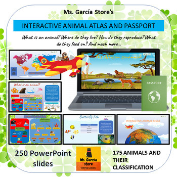
Interactive Animal Atlas and Ecologic Passport
By Ms Garcia Store
Journey through the Animal Kingdom with this captivating PowerPoint presentation! Join me aboard my plane and explore over 150 animals in their natural habitats and ecosystems. Discover their unique characteristics and classification within the animal world. Each animal has its own dedicated file, featuring an image, classification, and a 3 to 5-minute video about their fascinating lives. By clicking on different features, you'll be transported to new tabs that enhance your understanding of this incredible world.
This interactive resource ensures that all tiles are interconnected, providing a seamless learning experience. Plus, customization is a breeze. On slide 3, simply replace "Ms Garcia Store" with your own class name. For example, "Ms. Garcia's Class."
In addition, you'll receive two PDF files to complement your journey:
1. Ecological Passport: Print the 3 double-sided letter-size sheets (8.5 x 11") from this PDF and obtain a fantastic passport. Your students can familiarize themselves with this document while exploring different ecosystems.
2. Travel Stamps: Also print this 2-page PDF (single-sided). It features 20 travel stamps for your students to affix to their eco-passports as they learn about each location. The 20 stamps represent the following destinations:
- Amazon Rainforest
- Australia
- Andes Mountains
- The Arctic
- The Antarctic
- African Savannah
- American Grasslands
- American Swamps
- Pacific Coast
- Sahara Desert
- African Jungle
- Himalayan Mountains
- Indonesian Islands
- Galapagos Islands
- Asian Monsoon Rainforest
- Northern Forests
- European Forests
- Coral Reefs
- Farm Animals
- City Animals
Content:
- What is an animal?
Vertebrates
- Mammals
- Birds
- Fish
- Reptiles
- Amphibians
Invertebrates
- Poriferans
- Flatworms
- Annelids
- Echinoderms
- Cnidarians
- Mollusks
- Arthropods
- Arachnids
- Insects
- Crustaceans
- Myriapods
- Where do they live?
- 10 habitats
- 20 ecosystems
Travel around the world and explore 20 ecosystems while discovering the animals that inhabit them.
- How do they reproduce?
- Viviparous, oviparous, and ovoviviparous
- What do they eat?
- Carnivores
- Herbivores
- Omnivores
Students will practice form completion by providing the following information in the Passport, either their own personal information or that of an invented character:
- Surname
- Given Names
- Nationality
- Date of Birth
- Place of Birth
- Sex
- Date of Issue (the date the form is filled out)
- Date of Expiry (5 years after the date of issue)
- Signature
- Photo or Drawing of the Student's Face
Immerse yourself in this exciting virtual safari and let your students explore the captivating world of animals in diverse corners of the planet. Acquire this resource now and provide an unforgettable educational experience!
Note: This resource can be used in the classroom or for homeschooling purposes.
Related Products
⭐ Interactive animal atlas, animal classification, reproduction, habitats, etc.
⭐ Interactive Animal Atlas and Ecologic Passport
⭐ Safari virtual field trip around the world
⭐ Safari Virtual Fieldtrip and Ecologic Passport
⭐ Ecologic Passport and 20 Travel Stamps of different Ecosystems
Productos Relacionados
⭐ Atlas animal interactivo. Clasificación, reproducción, habitats...
⭐ Atlas animal interactivoy PasaporteEcológico
⭐ Safari virtual interactivoalrededordel mundo
⭐ Safari Virtual Interactivoy PasaporteEcológico
⭐ PasaporteEcológicoy sellosde viajede 20 ecosistemas
Click here to visit my TeachShare store
I would like to thank all the graphic designers whose work I took borrowed from these webs to do this educational resource:
Clipartkey.com
Background vector created by brgfx - www.freepik.com
Dog vector created by brgfx - www.freepik.com
Background vector created by macrovector - www.freepik.com
Tree vector created by upklyak - www.freepik.com
Vector de Fondo creado por macrovector - www.freepik.es
Nature Vectors by Vecteezy
Antarctica Vectors by Vecteezy
Antarctica Vectors by Vecteezy
Kids vector created by macrovector - www.freepik.com
Cartoon Jungle Vectors by Vecteezy
Animales Vectores por Vecteezy
Naturaleza Vectores por Vecteezy
Vintage vector created by rawpixel.com - www.freepik.com
Imagen de Clker-Free-Vector-Images en Pixabay
Image by Clker-Free-Vector-Images from Pixabay
Duck-billed platypus
Animals vector created by brgfx - www.freepik.com
Imagen de tony241969 en Pixabay
Imagen de Mostafa Elturkey en Pixabay
Food vector created by macrovector - www.freepik.com
Background vector created by rawpixel.com - www.freepik.com
Vintage photo created by rawpixel.com - www.freepik.com
Poster vector created by rawpixel.com - www.freepik.com
Nature Vectors by Vecteezy
Snow vector created by brgfx - www.freepik.com
Tree vector created by brgfx - www.freepik.com
Background vector created by brgfx - www.freepik.com
Texture photo created by freepik - www.freepik.com
Image by macrovector on Freepik
Image by brgfx on Freepik
Imagen de macrovector en Freepik
Imagen de macrovector en Freepik
The 7 Continents Reading Comprehension
By Elementary divas
Your students will learn about the 7 Continents of the world, while they read and answer the questions from the passages. Asia, Africa, Europe, North America, South America, Oceania, and Antarctica.
You might also be interested in these other resources:
- Opinion writing worksheets
- Sequence of events headings
- Sequence of events worksheets
- 57 Story Starters Picture Writing Prompts
- 384 CVC Words Pocket Chart SUPER Packet
- Compare and Contrast worksheets, Picture Cards and Poster
- CVC Middle Sound Words Pocket Chart
- Fraction Wall with 40 Task Cards, Posters
It is our sincere hope that you can find this resource useful.
If you like this product please be sure to leave positive feedback to earn TeachShare credits toward future purchases.
FIND US HERE!
Instagram
Email
Blog-coming soon!
7 CONTINENTS OF THE WORLD WORKSHEETS - Explore and Learn About Each Continent
By Just Be Creative Homeschooling
Are you looking for an effective way to teach kids about the geography and diversity of our planet? Our 7 Continents of the World Worksheets are the perfect educational tool! This comprehensive worksheet pack provides detailed activities for exploring each of the seven continents, helping children understand the unique characteristics, cultures, and geography of Asia, Africa, North America, South America, Antarctica, Europe, and Australia.
Ideal for classroom geography lessons, homeschooling, or at-home learning, these worksheets offer an engaging and interactive way to learn about the continents. Each worksheet is designed to be informative and fun, making geography accessible and interesting for young learners.
What’s Included in the 7 Continents of the World Worksheets Pack:
- Asia Worksheet: Explore the largest continent with activities focused on its diverse cultures, landscapes, and major landmarks.
- Africa Worksheet: Learn about Africa's rich history, vibrant ecosystems, and famous sites like the Sahara Desert and Nile River.
- North America Worksheet: Discover the geography, countries, and unique features of North America, from the Rocky Mountains to the Great Lakes.
- South America Worksheet: Delve into the diverse landscapes and cultures of South America, including the Amazon Rainforest and Andes Mountains.
- Antarctica Worksheet: Investigate the icy continent of Antarctica, its wildlife, and the significance of its polar environment.
- Europe Worksheet: Explore Europe's varied geography, historical significance, and major cities.
- Australia Worksheet: Learn about Australia's unique wildlife, the Outback, and its coastal wonders.
Features:
- Detailed Worksheets: Each continent worksheet includes activities and information to enhance learning about its geography, culture, and landmarks.
- Engaging Activities: Interactive tasks such as mapping, coloring, and matching exercises make learning fun.
- Educational Content: Provides key facts and insights into each continent, fostering global awareness.
- Printable Templates: Ready-to-use worksheets for immediate implementation in lessons or activities.
Help your students embark on a global journey with our 7 Continents of the World Worksheets, and watch them explore and learn about the diverse and fascinating continents of our planet in a fun and educational way!
IN ADDITION, this resource includes a helpful tip sheet about "Child Development and Play Activities." Through this resource, parents will gain practical insights into how different types of play contribute to their child's overall development. The information sheet provides simple and engaging ideas for fostering cognitive, physical, social, and emotional growth through play. By incorporating these activities, young learners can develop essential skills while enjoying the fun and creativity that play brings to their everyday lives.
SOLAR SYSTEM CRAFTS - Cut and Paste Crafts - Exploring the Planets
By Just Be Creative Homeschooling
Are you on the hunt for an engaging and creative way to spark your students' curiosity about the solar system? Look no further! Our "Solar System Cut and Paste Crafts" are the perfect resource to embark on an astronomical adventure while making learning about space an enjoyable experience.
Here's what you can expect from our Solar System Cut and Paste Crafts resource:
- Planet-by-Planet Exploration: Dive into the cosmos with a dedicated craft for each of the planets in our solar system. These hands-on activities allow students to learn about the planets while creating a captivating solar system display.
- Artistic Expression: Each craft comes in black and white, providing the perfect canvas for students to unleash their creativity. They can color, paint, or decorate each planet, making their solar system project truly unique.
- Hands-On Learning: The act of cutting, pasting, and assembling the planets fosters fine motor skills and dexterity, making it a valuable educational experience that goes beyond astronomy.
- Versatile Learning Tool: Whether you're a teacher looking for a classroom bulletin board activity, an educator seeking a whole-class project, or a homeschooling parent eager to enhance your curriculum, our Solar System Cut and Paste Crafts are adaptable to various learning environments.
- Thematic Immersion: Immerse your students in the wonders of the solar system, fostering a lifelong fascination with space. This thematic approach not only educates but also inspires a sense of awe and wonder about the cosmos.
Our "Solar System Cut and Paste Crafts" are a versatile and valuable addition to any learning setting. Whether you're teaching a group of eager students or providing individualized homeschooling, this resource is tailor-made for you. Watch as young learners bring the solar system to life with their artistic flair, making astronomy an unforgettable experience.
IN ADDITION, this resource includes an information handout about "The Earth." Through this resource, students will develop a better understanding of how the Earth works and why it is important to protect it.
Label the Maps and Globes Worksheets
By Jennifer Connett
Label different map and globe features with these cut and paste pages. There are map pages for labeling the hemispheres, oceans and continents.
What Pages are Included:
- Label the Continents on a map
- Label the Oceans on a map
- Label the Hemispheres on a map
- Label the equator, northern and southern hemispheres on a globe
- Label the equator, land and water on a globe
More Resources
United States Activities
Today in History Activities
Geography - Find that Country! Label and Color Worksheet
By Yugen Learning
In this fun and back to school, no prep lesson and emergency sub for your Geography program, students will embark on a geographical journey to find specific countries using an atlas or google earth skills to develop their country finding ability, before labelling and coloring in the map. All neatly contained within a single A4 sheet.
Enjoy this resource! Don't forget to follow my store for more awesome products and rate this product for your TeachShare credits :)
People that have purchased this resource have also purchased -
Geography | What Causes Hunger lesson activity
Geography | Analysing and Interpreting Population Pyramids
Geography | Geographical Scavenger Hunt
Geography | Hemispheres, Continents and Lines of Latitude Worksheet
Please leave a review.
Geography & Maths - Teaching Grid Coordinates with a Game with lesson plan
By Yugen Learning
Ahoy, educators! Dive into the world of coordinates with our engaging no prep Battleship Coordinates Game for you or an emergency sub lesson for your Geography and Maths programs.. Designed meticulously with students in mind, especially those who find coordinates challenging, this game offers a hands-on, interactive approach to mastering the X and Y axis f
Master Coordinates with the Battleship Game: A Fun & Engaging Learning Tool!
Resources:
- Lesson plan to help your implement
- Complete single A4 page with instructions and supporting information for all students (Simply duplicate and distribute)
Why Choose the Battleship Coordinates Game?
- Engaging Learning: Transform the daunting task of understanding coordinates into an exciting naval adventure!
- Tailored for Strugglers: Specifically crafted for students who find coordinates tricky, serving as an excellent introduction.
- Aligned with Standards: Our game is in sync with Common Core outcomes, ensuring your students are on track with curriculum standards.
- Dual Learning: While students immerse in strategic gameplay, they're simultaneously reinforcing their understanding of basic coordinates.
Common Core Outcomes:
- CCSS.Math.Content.5.G.A.1: Use a pair of perpendicular number lines, called axes, to define a coordinate system.
- CCSS.Math.Content.5.G.A.2: Represent real-world and mathematical problems by graphing points in the first quadrant of the coordinate plane.
Australian curriculum links: for teaching coordinates in geography and mathematics:
- ACGSE037: Use maps, globes, and other spatial representations to locate places and features.
- ACGSE043: Analyze the spatial distribution of people, places, and things.
- ACGSE051: Understand the impact of human activities on the environment.
- ACMNA066: Understand the concepts of coordinate geometry, including the Cartesian coordinate system.
- ACMNA067: Be able to plot points and lines in the Cartesian coordinate system.
- ACMNA068: Use coordinate geometry to solve problems.
- ACMNA069: Understand the relationship between coordinate geometry and other areas of mathematics, such as geometry and algebra.
Bring coordinates to life in your classroom and watch as your students navigate their way to success. Set sail into the world of interactive learning today!
Grab Your Battleship Coordinates Game Now!
Enjoy this resource! Don't forget to follow my store for more awesome products and rate this product for your TeachShare credits :)
People that have purchased this resource have also purchased -
Geography | What Causes Hunger lesson activity
Geography | Analysing and Interpreting Population Pyramids
Geography | Geographical Scavenger Hunt
Geography | Hemispheres, Continents and Lines of Latitude Worksheet
Please leave a review.
Geography - Dive Deep into the Seven Continents! Worksheet Booklet
By Yugen Learning
Overview: Introduce your students to the wonders of our world with this comprehensive 7-page no prep for you or an emergency sub Geography research booklet! Each page is dedicated to one of the seven continents, providing a detailed map and thought-provoking questions that will ignite their curiosity and deepen their understanding of global geography.
What's Inside:
Detailed Maps: Each continent is beautifully illustrated, offering students a clear visual representation to aid their research.
Research Questions: For every continent, students will delve into:
- Size/Area: Understand the vastness of each landmass.
- Number of Countries: Not just the count, but labeling them too!
- Population & Largest City: Dive into demographics.
- Highest Point: Reach the peak of knowledge!
- Climate: Discover the diverse weather patterns.
- Top Landmark: Identify iconic sights.
- Major Rivers and Lakes: Flow with the world's waterways.
- Mountain Ranges: Scale the heights of knowledge.
- Nearby Oceans and Seas: Explore the surrounding waters.
Benefits:
- Integrated Learning: This booklet promotes research skills, reading comprehension, and map reading all in one!
- Flexibility: Suitable for independent study, group work, or as a homework assignment.
- Engagement: The hands-on approach ensures students are actively involved in their learning journey.
Why Choose This Resource? As educators, we understand the importance of making learning engaging and relevant. This booklet has been meticulously designed to ensure students not only learn but also appreciate the diverse wonders our world has to offer. Whether you're introducing continents for the first time or looking for a resource to deepen existing knowledge, this booklet is your perfect companion.
Embark on a global adventure with your students today!
In this fun and back to school, no prep lesson your Geography program, students will embark on a geographical journey to find specific countries using an atlas or google earth skills to develop their country finding ability, before labelling and coloring in the map. All neatly contained within a single A4 sheet.
Enjoy this resource! Don't forget to follow my store for more awesome products and rate this product for your TeachShare credits :)
People that have purchased this resource have also purchased -
Geography | What Causes Hunger lesson activity
Geography | Analysing and Interpreting Population Pyramids
Geography | Geographical Scavenger Hunt
Geography | Hemispheres, Continents and Lines of Latitude Worksheet
Please leave a review.
World Geography - Geographical Scavenger Hunt Printable and Digital activity
By Yugen Learning
If you are looking for a creative and no-prep, self contained for emergency sub resource for middle of high school to teach about world geography Map Labelling Challenge. This printable and digital activity works as bellringer or ongoing task to teach or assess your students about geographical knowledge locations from oceans to countries for your Geography program.
In this no prep lesson, Geographical Scavenger Hunt to identify continents, oceans, seas, mountains ranges, bays, gulfs, rivers, countries, latitude & longitude lines on world map and is suitable for students for a back to school tasks to to test and revise their geographical information.
Geographical Map Labelling Challenge
Objective: To enhance students' knowledge of the world's geography by identifying and naming various geographical features using a numbered world map.
Task:
Using the numbers as references, students must identify and label the following:
- Continents: All the continents marked on the map.
- Oceans: All the major oceans indicated.
- Rivers: Major rivers that are numbered.
- Mountain Ranges: Identify the mountain ranges marked on the map.
- Bays and Gulfs: Label the bays and gulfs indicated.
- Lines of Latitude & Longitude: Identify and label the major lines of latitude (e.g., Equator, Tropics) and longitude (e.g., Prime Meridian).
- Countries: Label as many countries as possible that are numbered on the map.
Resources includes
- Digital worksheet
- Printable worksheet
- Marking key
I like starting with them working singly to answer as many as they can, then moving on working in groups. Finally using an atlas to complete the sheet. Or you can use it as an ongoing start/end of lesson task for the first/last 5 minutes. Student love the challenge.
Extension Activities:
- Ask students to research and write a brief description of a geographical feature they found challenging to identify.
- Organize a group discussion where students can share interesting facts about a particular country or geographical feature they labeled.
- Encourage students to create a visual presentation or poster showcasing a specific continent and its unique geographical features.
This task promotes active learning as students engage with the map, utilize their geographical knowledge, and collaborate with peers to identify and label the world's major features.
Common Core
RH.6-8.7 Integrate visual information (e.g., in charts, graphs, photographs, videos, or maps) with other information in print and digital texts.
Australian Geography Curriculum link:
Challenges to food production, including land and water degradation, shortage of fresh water, competing land uses, and climate change, for Australia and other areas of the world (ACHGK063)
Upon completing your purchase, you will click on the green button that says Add to Google Drive. Then, you will be able to find this resource in the TeachShare Purchases folder of your Google Drive account! If you have any technical issues, reach out to us at yugenlearning@gmail.com or contact TeachShare.
Enjoy this resource! Don't forget to follow my store for more awesome products and rate this product for your TeachShare credits :)
People that have purchased this resource have also purchased -
Curriculum resources can be accessed here
Geography
$ Economics
Medieval History
✅ ➡ World War One
✅ ➡ Nazi Germany
✅ ➡ ✈ World War Two
✅ ➡ v ☭️ Cold War
✅ ➡ Australian History
✅ ➡ ⚙ Industrial Revolution
✅ ➡ USA History
✅ ➡ American Revolution
✅ ➡ ⚔ US Civil War
✊ USA Civil Rights
and
Subscribe to my Teaching Newsletter for a History Teachers AI guide and one of my best selling history resources.
Follow us!!!!!
https://www.instagram.com/yugenlearning/
https://www.pinterest.com.au/yugenlearning/
TeachShare Store
https://www.TeachShare.com/Store/Yugen-Learning
Please share feedback to help me improve my resources for you.
Geography - Hemispheres, Continents and Lines of Latitude Worksheet
By Yugen Learning
In this no prep lesson for you or an emergency sub in your Geography program, students will embark on a geographical journey to explore the intricate details of our world's layout. They will be provided with a detailed map, which will serve as their canvas to mark and identify the lines of latitude, distinguish between the different hemispheres, and pinpoint the continents. As they navigate through the map, students will also encounter a series of questions designed to test their understanding and observation skills.
Task:
Using the numbers as references, students must identify and label the following:
- Continents
- Oceans
- Continents
- Hemispheres
- Lines of Latitude
Develop mate reading skills and visual recombination skills
Resources:
A3 size sheet
Marking key
Enjoy this resource! Don't forget to follow my store for more awesome products and rate this product for your TeachShare credits :)
People that have purchased this resource have also purchased -
Geography | What Causes Hunger lesson activity
Geography | Analysing and Interpreting Population Pyramids
Geography | Geographical Scavenger Hunt
Please leave a review.