$5 - $10 3rd Grade Geography Resources
Black and White Coloring and Quick Facts of all 50 USA states : unit study
By Tomorrowcomes
Updated with new 2024 flags!
Black and White Quick Facts and Coloring page of all 50 States. Each sheet has the shape and capital of the state, state flower, flag, abbreviation, date and rank of statehood, area and rank, population and rank, region, and state slogan. This is a great resource to introduce basic facts of individual states, while students can engage thru coloring the state flower, map, and flag. Also included is a map of the United States of America. You can have your students label the states and color based on region.
Check out this US President Worksheet covering from George Washington to Joseph Bidden!
By Creative Soul Printables
Explore the diverse and fascinating United States of America with our 50 States Notebook Pages. This educational and engaging product is designed to help students and travelers of all ages learn more about each of the 50 states that make up this vast and culturally rich nation. Whether you're a student researching state history, a traveler planning a road trip, or an educator looking for engaging teaching resources, these notebook pages are the perfect companion.
Key Features:
- Comprehensive Coverage: Each state has its dedicated page, providing an in-depth overview of its history.
- Beautifully Illustrated: Vibrant and detailed illustrations bring each state to life, making the learning experience more enjoyable and visually appealing.
- Customizable Format: The notebook pages are thoughtfully designed to be easily printable and fit into standard notebooks or binders. You can create your personalized 50 States Notebook by arranging the pages in any order that suits your needs.
- State Flags and Symbols: Learn about the unique state flags, official seals, and other symbols that represent the identity and heritage of each state.
- Great for All Ages: Whether you're a curious youngster or an adult seeking to expand your knowledge, these notebook pages are suitable for learners of all ages and backgrounds.
- Educational Tool: Ideal for homeschooling, classroom teaching, or self-study, the 50 States Notebook Pages are a valuable resource for educators, parents, and students alike.
Uses:
- Education: Perfect for integrating state-specific knowledge into social studies, geography, or history lessons.
- Travel Planning: Plan your dream road trip across the United States, knowing more about each state you'll visit.
*************************************************************
What is included:
Map to write in abbreviations of states to know locations
Notebook Pages for all 50 States
Images for state trees, seals, flags, flowers, birds and flowers
*************************************************************
Other Related Products that May Interest You:
⭐ 50 States Abbreviations BINGO
⭐ 50 States BINGO
**************************************************************
How to get TeachShare credit to use on future purchases:
Please go to your “My Purchases” page (you may need to login). Beside each purchase you'll see a Provide Feedback button. Simply click it and you will be taken to a page where you can give a quick rating and leave a short comment for the product.
Each time you give feedback, TeachShare gives you feedback credits that you use to lower the cost of your future purchases. I value your feedback greatly as it helps me determine which products are most valuable for your classroom so I can create more for you.
Be the first to know about my new discounts, freebies and product launches: Check out my store to know first! **************************************************************
Landmarks of Ancient Egypt * 3rd-8th Grade * Worksheets
By Christa Nonnemaker
This Ancient Egypt Landmarks Resource includes historical terms, a timeline, information about significant landmarks, maps, and pages for categorizing, labeling, identifying and evaluating. An additional page offers questions for students to consider as well as project ideas.
Fifteen separate landmarks are described with engaging photographs included. Students are able to complete as written worksheets or digitally via Easel.
This is a great way for students learn about Ancient Egypt and the geography of Egypt.
Refer to the "History of Ancient Egypt" two-page Guided Reading resource for more information about the key eras in ancient Egyptian history.
Alaska Research Project with Reading Comprehension and Time Line
By Jennifer Connett
Learn about the history of Alaska and its state symbols with this state research project. This Alaska research project contains cards with real pictures, reading passages with comprehension questions, and two forms of research recording activities. Students can use the passages, posters and cards to answer the research questions in the two books, or conduct their own research through books or the internet. The preview shows a sampling of each part of this packet.
What is included?
Basic State Poster
State Symbol Cards with real photographs where available
History Time Line Cards with real photographs where available
Reading Comprehension Passages
- Alaska History
- Weather and Climate
- Agriculture and Industry
Fun Facts and Information Pages
Writing Activities
State Research Flip Book Pages
- Basic Facts
- Where is this State?
- Major Landmarks
- Flag
- State Symbols
- Interesting Facts
State Report Book Pages (Choose the pages according to what your focus is.)
- Basic Facts
- Location
- Flag
- State Map
- State Symbols
- Major Landmarks
- Weather and Climate
- Industry and Agriculture
- Famous Person
- Fun Facts
Related Links:
More United States Activities
Susan Wise Bauer "Volume 2: The Middle Ages" worksheets
By Peter D
This is a 98-page set of worksheets to accompany Susan Wise Bauer's book "Volume 2: The Middle Ages" from the Story of the World.
These worksheets are compatible with both the original edition and the revised edition (published in 2021). Both editions have essentially the same content, and the publisher states that in the revised edition, improvements were made to maps, illustrations, and typesetting, but no new content was added.
For each chapter, there is one page of comprehension questions (multiple choice and short answer questions).
For each set of six chapters, there are eight review pages:
* comprehension questions (multiple choice)
* comprehension questions (short answer questions)
* vocabulary (two pages)
* review activity
* compare and contrast
* illustrations
* paragraph summaries
Also, there is an answer key included at the end of the file.
Worksheets for nonfiction books:
* Carl Sagan: Cosmos
* I Am Malala
* Malala's Magic Pencil
* Roald Dahl: Boy (Tales of Childhood)
* Roald Dahl: Going Solo
* Steck-Vaughn textbook: History of our World Volume 1
* Steck-Vaughn textbook: History of our World Volume 2
* Elie Wiesel: Night
* Susan Wise Bauer: Volume 1 (Ancient Times)
* Susan Wise Bauer: Volume 2 (The Middle Ages)
* Susan Wise Bauer: Volume 3 (Early Modern Times)

World Map Worksheets | 7 Continents and 5 Oceans Blank Map Skills & Activities
By Innovative Classroom Ideas
Kids enjoy studying about the world in which they live! With the help of these entertaining printable Continents and Oceans Worksheets, they will love learning about the seven continents and the corresponding geography. For students in kindergarten, first grade, second grade, third grade, fourth grade, fifth grade, and sixth grade, these worksheets offer a fun and interactive way to explore our planet. Through engaging activities like coloring, labeling, and matching, students will develop a solid understanding of the continents and oceans while sparking their curiosity about the diverse cultures and natural wonders of the world. Let’s embark on a global adventure together!
By completing the various activities, children will enhance their map skills, vocabulary, and critical thinking abilities. These printable resources are perfect for homeschooling, classroom use, or simply as a fun activity to do at home.
These no prep worksheets offer a wide range of activities to keep young learners engaged. From simple tracing and coloring to more challenging puzzles and word searches, there’s something for everyone. With these worksheets, learning about the continents and oceans is both educational and enjoyable.
✅ Save more than 50% when you get a bundle ✅
This bundle contains the following resources:
⭐ Blank World Map with Countries | 7 Continents and 5 Oceans | United States Map
These printable maps will be useful whether you are studying geography, world history, countries around the world, or you are just trying to show your kids the route you are taking on your next vacation! For kids learning about states, we’ve included a printable map of the world, as well as maps of North and South America, Europe, Asia, Australia, Africa, and Antarctica. Furthermore, the world map printable set comprises labeled and blank options for printing. To print the printable map pdf file simply download this ressource and use it for students in pre-kindergarten, first grade, second grade, third grade, fourth grade, fifth grade, sixth grade, seventh grade, junior high, and even high school.
The blank world map is particularly useful for providing a bird’s eye perspective of the globe, oceans, continents, and major nations. It also helps locate me on the map with children of various ages.
That ressource countains:
- Blank World Map (with /without country names)
- North America Map (with / without country names)
- South America Map (with / without country names)
- Australia Map (with / without country names)
- Asia Map (with / without country names)
- Europe Map (with / without country names)
- Antarctica Map (with / without country names)
- Africa Map (with / without country names)
- United States Map (with / without country names)
⭐ World Map with Countries Worksheets | 7 Continents and 5 Oceans Blank Map
Kids enjoy studying the world they live in! They will enjoy learning about the seven continents and the corresponding geography with these fun and printable Continents Worksheets. For kindergarteners, first graders, second graders, third graders, fourth graders, and fifth graders, use these continents and oceans worksheets. You may start playing and learning as soon as you print the continents and oceans worksheet PDF.
These 7 continents and 5 oceans worksheets are perfect for parents, teachers, and homeschoolers who want to assist their kids learn about the globe we live in and improve their science skills. For kindergarteners, first-graders, second-graders, third-graders, fourth-graders, and fifth-graders, this pack is ideal. Use these no prep 7 Continents worksheets for science centers, additional practice, at home or at school, or as a component of a continent study. Children will learn about the seven continents that today make up the world in which we live with this bundle. Answers are provided and this pack comes mainly in black and white with a few color pages thrown in.
There are lots of activities in this pack:
- Continent poster in color
- Color in the continents on the world map following the key
- Cut out and paste the labels onto the continents
- Write the names of the seven continents next to the corresponding number
- Color in the continents using the key
- Unscramble the names of the continents
- One page for each of the seven continents with facts that include the hemisphere the continent is in, the oceans that surround it, and the amount of countries that are in that continent
- Write the names of the continents in alphabetical order
- Continent word search
⭐ Continents and Oceans Worksheets | Blank World Map with Countries | Map Skills
This set of printable pages on the seven continents is a fantastic way to practice geography. With the help of this continents and oceans worksheet pdf, students will enjoy learning about the seven major continents. Use these maps with kindergarten, first, second, third, fourth, fifth, and sixth grade elementary students as part of a social studies subject, as a stand-alone review, or as additional practice.
These 7 Continents and 5 Oceans worksheets will be a hit with your pupils as they practice labeling the different continents and discover fascinating facts about each one. You only need to print the continents and oceans worksheet to begin teaching kindergarteners, first-graders, second-graders, third-graders, fourth-graders, fifth-graders, and sixth-graders. This no-prep geography lesson will help children learn about Asia, Africa, Australia, North America, Antarctica, South America, and Europe. It is perfect for parents, teachers, and homeschoolers. Now that you have these continents worksheets, you can start learning! The answer key is provided!!
⭐ World Map Skills Worksheets | 7 Continents and 5 Oceans | Geography Activities
This printable page pack featuring the seven continents is an excellent tool for honing geography skills. These continents and oceans worksheet pdf will make learning about the seven major continents enjoyable for students. Utilize these no prep worksheets with kindergarten, first, second, third, fourth, fifth, and even sixth graders! With vibrant colors and engaging activities, these worksheets turn geography into an adventure. Children will love coloring the continents, labeling oceans, and matching animals to their habitats. Perfect for homeschooling, classroom use, or simply for curious young minds. Let’s explore the world together!
From basic map skills to understanding cultural differences, these no prep continents and oceans worksheets provide a solid foundation for future learning. Download your set today and start your global exploration! Students will love searching for hidden objects, solving puzzles, and creating their own maps. These engaging activities will spark their curiosity and inspire a lifelong love of geography. Plus, they’re a great way to reinforce essential skills like following directions and problem-solving.
>>>> ⭐ More Similar Activities ⭐ <<<<<
We adore FEEDBACK! You also obtain CREDITS! :
- Access your TeachShare account by logging in.
- Select "My TeachShare" from the drop-down menu.
- Click on "My Purchases."
- Select ratings and provide feedback.
Terms of Use: By purchasing and/or downloading this electronic file, you are allowed to use the product for personal use as you like, but you are not allowed to resell or redistribute.
Follow my store and get all the newest product updates and freebies by clicking the green star ★ above.
♥ Search Key Terms: World map, world maps, world, world geography, map of the world, world map is wrong, world map for kids, world facts, map of world, #world, new world map, free world map, accurate world map, world puzzle, world oceans, fixing the world map, World map, world,blank map, how to draw world map easily, world map drawing, how to draw world map, world maps,European school draw world map, world map drawing easy, world map draw kaise kare, world map flat, world map draw in ias mains exam, how to draw a world map in easy steps, world map quiz, easy world map, how to draw world map in examination, how to dry world map in upsc mains exam, Continents and oceans, the continents and oceans of the world worksheet, continents and oceans for kids, continents and oceans for kids, continents and oceans workbook, continents and oceans free course, continents and oceans printables, homeschool continents and oceans, classroom continents and oceans resources, homeschool continents and oceans resources, oceans and continents, Map skills, map skills for kids, map skill, skills,map symbols,, map,map skills tutorial, map skills geography,map skill of India, reading a map, map reading skills, map skill for third grade, map scales, how to teach map skills to students, how to teach map skills to students, mapping skills, map skill of ch 3 drainage class 9 geography, navigational skills., #maps, reading a map for kids, map legends, hiking skills, how to make a map, how to read a map
New York State Geography Scavenger Hunt (No prep!)
By Miss Yous Clues and Resources
This is a scavenger hunt using task cards that is based on New York State Geography which is aligned with the 4th grade curriculum but would be helpful for grades 3-5 learning about New York State. Students will read about the lakes, rivers, mountain ranges, cities within NYS, the state capital, bordering states, countries and oceans. Check out the preview to see what each task card entails. Students will need to walk around the room reading the task cards. Each task card has a code word on the bottom which is the answer to the question/fill in the blank. The answer will NOT be found on that same task card. For example, the answer to task card #1 is found by reading the passage on task card #8. Students MUST record which task card they found the answer on in their answer sheet under the “FOUND CARDS #” column. That column will be used at the end for the 4 digit lock code. They will follow the clues to find the correct 4 digit code.
This activity would be a great review before assessments, as a center activity, a group activity, etc. Students will be engaged with the learning while having a fun time trying to solve all of the clues!
Geography - Dive Deep into the Seven Continents! Worksheet Booklet
By Yugen Learning
Overview: Introduce your students to the wonders of our world with this comprehensive 7-page no prep for you or an emergency sub Geography research booklet! Each page is dedicated to one of the seven continents, providing a detailed map and thought-provoking questions that will ignite their curiosity and deepen their understanding of global geography.
What's Inside:
Detailed Maps: Each continent is beautifully illustrated, offering students a clear visual representation to aid their research.
Research Questions: For every continent, students will delve into:
- Size/Area: Understand the vastness of each landmass.
- Number of Countries: Not just the count, but labeling them too!
- Population & Largest City: Dive into demographics.
- Highest Point: Reach the peak of knowledge!
- Climate: Discover the diverse weather patterns.
- Top Landmark: Identify iconic sights.
- Major Rivers and Lakes: Flow with the world's waterways.
- Mountain Ranges: Scale the heights of knowledge.
- Nearby Oceans and Seas: Explore the surrounding waters.
Benefits:
- Integrated Learning: This booklet promotes research skills, reading comprehension, and map reading all in one!
- Flexibility: Suitable for independent study, group work, or as a homework assignment.
- Engagement: The hands-on approach ensures students are actively involved in their learning journey.
Why Choose This Resource? As educators, we understand the importance of making learning engaging and relevant. This booklet has been meticulously designed to ensure students not only learn but also appreciate the diverse wonders our world has to offer. Whether you're introducing continents for the first time or looking for a resource to deepen existing knowledge, this booklet is your perfect companion.
Embark on a global adventure with your students today!
In this fun and back to school, no prep lesson your Geography program, students will embark on a geographical journey to find specific countries using an atlas or google earth skills to develop their country finding ability, before labelling and coloring in the map. All neatly contained within a single A4 sheet.
Enjoy this resource! Don't forget to follow my store for more awesome products and rate this product for your TeachShare credits :)
People that have purchased this resource have also purchased -
Geography | What Causes Hunger lesson activity
Geography | Analysing and Interpreting Population Pyramids
Geography | Geographical Scavenger Hunt
Geography | Hemispheres, Continents and Lines of Latitude Worksheet
Please leave a review.
3rd-5th Social Studies: Geography Unit Text Passages, Guided Notes & Activities
By Kile's Classroom
Make your Social Studies Lesson SHINE!
This is a single unit of study for Social Studies- Geography. These activities will help your students deepen their knowledge of geography basics. The pages of this unit can be used as a supplemental activity for your current social studies curriculum, or you can use reading from the internet.
Easy-to-understand texts are included with each lesson. These texts can be used as stand-alone reading materials or supplements to your current Social Studies curriculum.
Topics Covered:
Lesson 1: North America
Lesson 2: Regions of the United States
Lesson 3: Canada
Lesson 4: Mexico
Lesson 5: The Caribbean
Unit Assessment Included
Additional Social Studies Resources from Kile's Classroom:
- Regions of the US Digital Project
- Free- Biography Trading Cards Project
- Government
- 4th-6th Grade Social Studies US Colonies Unit, Vocabulary, Texts, Activities
Customer Tips:
How to get TeachShare credit to use on future purchases:
• Please go to your My Purchases page (you may need to
log in). Beside each purchase, you'll see a Provide Feedback button.
Simply click it, and you will be taken to a page where you can give a quick rating and leave a short comment for the product. Each time you give feedback, TeachShare gives you feedback credits that you use to lower the cost of your future purchases. I value your feedback greatly as it helps me determine which products are most valuable for your classroom so I can create more for you. ☺
Be the first to know about my new discounts, freebies, and product launches:
• Look for the green star next to my store logo and
click it to become a follower. Voila! You will now receive email updates
about this store. ☺
Engaging Dia de los Muertos Activities | Teach Cultural Diversity | ELA Focused
By Sweet Maple Teaching
Are you looking for engaging Day of the Dead activities for kids to celebrate Día de los Muertos for October 31st-November 2nd? Your students can learn will love learning about Dia de los Muertos with many different activities to keep them engaged. You can use these materials as whole group work packet, small group, individual work, or thematic station materials. These activities are mostly no prep and easy to put together.
What's Included:
- Coloring Page
- All about Mexico Page
- World map
- Travel tickets to visit Mexico for Dia de los Muertos
- KWL chart
- Word search
- Word scramble
- Making words
- Game of words
- Acrostic poem
- Syllable sort
- Word sort
- Five senses of Dia de los Muertos
- Holidays of Mexico
- Comprehension passages
- QR code for youtube videos
- Compare & contrast holidays
- Write about Dia de los Muertos
- Color by vowels
- Vocabulary posters
- Vocabulary matching cards (picture, word, definition)
- Vocabulary word template
- I can, has, is worksheet
- picture vocabulary posters
- Tissue paper marigolds
- Sugar skull craft
It is important to teach about different cultures and traditions around the world. Your students will love learning about Dia de los Muertos. Your students can contribute to the understanding of this holiday and find an appreciation for the wonderful traditions found within this holiday.
TeachShare Credit to Use on Future Purchases:
Log into your account and find your my purchases page. Next to each purchase, you'll see a feedback button. You'll be able to click it, give a quick rating, and leave a short comment about the product. Each time you give feedback, TeachShare gives you feedback credits that you can use toward your future purchases. I value your feedback greatly as it helps us decide what is important to our wonderful customers.

¡Aventura Animal: Exploración Interactiva de 150 Animales y Ecosistemas
By Ms Garcia Store
¡Embárcate en una emocionante aventura con nuestro bundle educativo interactivo sobre el fascinante mundo de los animales! Este completo conjunto de recursos incluye:
1. Presentación Interactiva en PowerPoint: Sube a bordo de nuestro avión virtual y explora más de 150 animales en sus hábitats y ecosistemas. Cada animal cuenta con una ficha informativa que incluye una imagen, clasificación y un video de 3 a 5 minutos que resalta sus características únicas. Interactúa con los elementos de cada diapositiva para profundizar en el conocimiento de cada especie. Personaliza fácilmente la presentación reemplazando "Ms Garcia Store" con el nombre de tu clase.
2. Pasaporte Ecológico: Imprime y arma un encantador pasaporte ecológico con 3 hojas a doble cara (tamaño carta, 8.5 x 11"). Este pasaporte introduce a los estudiantes en los diferentes ecosistemas y les ayuda a comprender la diversidad de hábitats.
3. Sellos de Viaje: Incluye un PDF de 2 páginas con 20 sellos de viaje representando destinos como la Selva Amazónica, el Ártico y las Islas Galápagos. Los estudiantes pueden pegar estos sellos en sus pasaportes ecológicos mientras aprenden sobre cada ubicación.
4. Diario del Explorador de Animales: Un recurso educativo que cubre:
- Clasificación de los animales (vertebrados e invertebrados).
- Hábitats y ecosistemas globales.
- Reproducción y alimentación de los animales.
- Ejercicios para completar formularios en el Pasaporte Ecológico.
¡Permite que tus estudiantes se sumerjan en un safari virtual y descubran el magnífico mundo animal en sus diversos hábitats! Ideal para uso en el aula, en el hogar o en educación a distancia. ¡Adquiere este recurso ahora para ofrecer una experiencia educativa inolvidable!
Related Products
⭐ Interactive animal atlas, animal classification, reproduction, habitats, etc.
⭐ Interactive Animal Atlas and Ecologic Passport
⭐ Safari virtual field trip around the world
⭐ Safari Virtual Fieldtrip and Ecologic Passport
⭐ Ecologic Passport and 20 Travel Stamps of different Ecosystems
Productos Relacionados
⭐ Atlas animal interactivo. Clasificación, reproducción, habitats...
⭐ Atlas animal interactivoy PasaporteEcológico
⭐ Safari virtual interactivoalrededordel mundo
⭐ Safari Virtual Interactivoy PasaporteEcológico
⭐ PasaporteEcológicoy sellosde viajede 20 ecosistemas
Click here to see all my resources in Spanish
Click here to visit my TeachShare store
I would like to thank all the graphic designers whose work I took borrowed from these webs to do this educational resource:
Clipartkey.com
Background vector created by brgfx - www.freepik.com
Dog vector created by brgfx - www.freepik.com
Background vector created by macrovector - www.freepik.com
Tree vector created by upklyak - www.freepik.com
Vector de Fondo creado por macrovector - www.freepik.es
Nature Vectors by Vecteezy
Antarctica Vectors by Vecteezy
Antarctica Vectors by Vecteezy
Kids vector created by macrovector - www.freepik.com
Cartoon Jungle Vectors by Vecteezy
Animales Vectores por Vecteezy
Naturaleza Vectores por Vecteezy
Vintage vector created by rawpixel.com - www.freepik.com
Imagen de Clker-Free-Vector-Images en Pixabay
Image by Clker-Free-Vector-Images from Pixabay
Duck-billed platypus
Animals vector created by brgfx - www.freepik.com
Imagen de tony241969 en Pixabay
Imagen de Mostafa Elturkey en Pixabay
Food vector created by macrovector - www.freepik.com
Background vector created by rawpixel.com - www.freepik.com
Vintage photo created by rawpixel.com - www.freepik.com
Poster vector created by rawpixel.com - www.freepik.com
Nature Vectors by Vecteezy
Snow vector created by brgfx - www.freepik.com
Tree vector created by brgfx - www.freepik.com
Background vector created by brgfx - www.freepik.com
Texture photo created by freepik - www.freepik.com
Image by macrovector on Freepik
Image by brgfx on Freepik
Imagen de macrovector en Freepik
Imagen de macrovector en Freepik

Special Education Science Task Box Activity Bundle (Life Skills Activities)
By Specifically Sped
Special Education Science Task Box Puzzle Bundle
This special education science task box bundle is perfect for life skills classes. It is differentiated to meet the needs or multi-level students. The visuals provide students access to the material who may need more academic support.
Students can practice cutting and gluing these visuals to the matching board or laminate and add velcro for repeated use.
Included in the bundle are the following task box puzzles:
- Bodies of Water
- Landforms
- Continents
- Planets
- My Body
- My Organs
- Weather
- Animal Habitats
- Force and Motion
***FREEBIE INCLUDED
There is a free copy of "My Life Cycle Puzzle" available for you to download with this purchase of this bundle.
Mega Bundle
These task box puzzles are included in a mega bundle with corresponding adapted books. For each task box in this bundle their is an adapted book with matching visuals to reinforce the retention of each topic. With nine topics included, you are able to change these out each month.
Check out the Mega Bundle HERE!
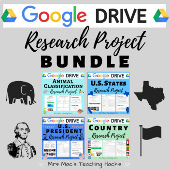
Google Drive Research Project BUNDLE
By Abigail J McClellan
Are you looking for online resources to assign your students so they can continue learning from home? Look no further! This comprehensive GOOGLE DRIVE research project BUNDLE is everything you need in order for students to complete independent research from home or paperless assignments at school. This product encourages research skills using National Geographic Kids & various graphic organizers, content-specific vocabulary knowledge, and self-reflection skills! This resource comes with over 12 pages per product of graphic organizers (with examples!), vocabulary terms, and Google Survey/Quizzes for easy grading. It is easy to use and an awesome independent research project that your students will love! Be sure to check out the individual products for a more detailed description / preview of what is included :)
This bundle includes:
Animal Classification Research Project
U.S. President Research Project
U.S. State Research Project
Country Research Project
What is included?
- Access to all 4 Google Drive products, each containing 8-9 resources (30 files total!!):
- How-to-Use Guide - Includes main ideas, student outcomes, materials, standards/curriculum connections, and assessment/grading.
- National Geographic Kids Website Guide - Provides a detailed description of how to use the National Geographic Kids website, including pictures and steps.
- Vocabulary Terms - ½ sheet definitions of 8 vocabulary words related to each project.
- Vocabulary Quiz - This 8 question quiz assesses the students on their knowledge of the vocabulary words from the vocabulary terms given.
- Individual Research Graphic Organizer - Graphic organizers for students to record their individualized research. It includes an example.
- Student Checklist and Project Reflection - This is the final part of the research project. Students are asked to fill out a checklist marking if they completed all aspects of the research project. They then can reflect on a few short answer questions.
- Terms of Use page
E-Learning / Home Learning / Remote Learning / Distance Learning / COVID-19 / Coronavirus / Paperless
Freebies & Discounts:
Be sure to follow my store by clicking HERE to stay up to date on all my new products, including products that are FREE and on discount!
Ratings & Reviews:
Please leave a review if you enjoyed this product and found it useful. I really love reading how you are using my products in your classroom :) Every time you give feedback, TeachShare gives you feedback credits that you use towards future products!! Thank you in advance for taking the time to leave a rating & review!
By The Book Bandit
This 40 page resource is a student resource all about Australia and is suitable for elementary and primary school aged children. The resource includes information over a wide range of topics with engaging questions and activities to go alongside them. Information to complete the activities is in the resource.
Topics include
- Australian Map
- Australia Profile
- Australia - General Knowledge
- Australian History
- Indigenous Australians
- Language and slang
- Money
- Boomerangs
- Wildlife
- Sport
- National Icons
- National Treasures
- Opportunities for students to apply their knowledge.
Please see the preview for a snapshot of some of the activities and information in this resource.
The 7 Continents Reading Comprehension
By Elementary divas
Your students will learn about the 7 Continents of the world, while they read and answer the questions from the passages. Asia, Africa, Europe, North America, South America, Oceania, and Antarctica.
You might also be interested in these other resources:
- Opinion writing worksheets
- Sequence of events headings
- Sequence of events worksheets
- 57 Story Starters Picture Writing Prompts
- 384 CVC Words Pocket Chart SUPER Packet
- Compare and Contrast worksheets, Picture Cards and Poster
- CVC Middle Sound Words Pocket Chart
- Fraction Wall with 40 Task Cards, Posters
It is our sincere hope that you can find this resource useful.
If you like this product please be sure to leave positive feedback to earn TeachShare credits toward future purchases.
FIND US HERE!
Instagram
Email
Blog-coming soon!

50 States black and white printable worksheets, facts, and coloring bundle
By Tomorrowcomes
Black and White Quick Facts and Coloring page of all 50 States. Each sheet has the shape and capital of the state, state flower, flag, abbreviation, date and rank of statehood, area and rank, population and rank, region, and state slogan. This is a great resource to introduce basic facts of individual states, while students can engage thru coloring the state flower, map, and flag. Also included is a map of the United States of America. You can have your students label the states and color based on region.
Black and White worksheet for cats on all 50 States. Each sheet asks basic information about individual states for students to fill out. This is a great resource to introduce basic facts of individual states, while students can engage thru drawing the state flower, state bird, state tree, and state shape. A blank worksheet is also included.
Check out this US President Worksheet covering from George Washington to Joseph Bidden!
Susan Wise Bauer "Volume 3: Early Modern Times" worksheets
By Peter D
This is a 98-page set of worksheets to accompany Susan Wise Bauer's book "Volume 3: Early Modern Times" from the Story of the World.
These worksheets are compatible with both the original edition and the revised edition (published in 2021). Both editions have essentially the same content, and the publisher states that in the revised edition, improvements were made to maps, illustrations, and typesetting, but no new content was added.
For each chapter, there is one page of comprehension questions (multiple choice and short answer questions).
For each set of six chapters, there are eight review pages:
* comprehension questions (multiple choice)
* comprehension questions (short answer questions)
* vocabulary (two pages)
* review activity
* compare and contrast
* illustrations
* paragraph summaries
Also, there is an answer key included at the end of the file.
Worksheets for nonfiction books:
* Carl Sagan: Cosmos
* I Am Malala
* Malala's Magic Pencil
* Roald Dahl: Boy (Tales of Childhood)
* Roald Dahl: Going Solo
* Steck-Vaughn textbook: History of our World Volume 1
* Steck-Vaughn textbook: History of our World Volume 2
* Elie Wiesel: Night
* Susan Wise Bauer: Volume 1 (Ancient Times)
* Susan Wise Bauer: Volume 2 (The Middle Ages)
* Susan Wise Bauer: Volume 3 (Early Modern Times)
Geography & Maths - Teaching Grid Coordinates with a Game with lesson plan
By Yugen Learning
Ahoy, educators! Dive into the world of coordinates with our engaging no prep Battleship Coordinates Game for you or an emergency sub lesson for your Geography and Maths programs.. Designed meticulously with students in mind, especially those who find coordinates challenging, this game offers a hands-on, interactive approach to mastering the X and Y axis f
Master Coordinates with the Battleship Game: A Fun & Engaging Learning Tool!
Resources:
- Lesson plan to help your implement
- Complete single A4 page with instructions and supporting information for all students (Simply duplicate and distribute)
Why Choose the Battleship Coordinates Game?
- Engaging Learning: Transform the daunting task of understanding coordinates into an exciting naval adventure!
- Tailored for Strugglers: Specifically crafted for students who find coordinates tricky, serving as an excellent introduction.
- Aligned with Standards: Our game is in sync with Common Core outcomes, ensuring your students are on track with curriculum standards.
- Dual Learning: While students immerse in strategic gameplay, they're simultaneously reinforcing their understanding of basic coordinates.
Common Core Outcomes:
- CCSS.Math.Content.5.G.A.1: Use a pair of perpendicular number lines, called axes, to define a coordinate system.
- CCSS.Math.Content.5.G.A.2: Represent real-world and mathematical problems by graphing points in the first quadrant of the coordinate plane.
Australian curriculum links: for teaching coordinates in geography and mathematics:
- ACGSE037: Use maps, globes, and other spatial representations to locate places and features.
- ACGSE043: Analyze the spatial distribution of people, places, and things.
- ACGSE051: Understand the impact of human activities on the environment.
- ACMNA066: Understand the concepts of coordinate geometry, including the Cartesian coordinate system.
- ACMNA067: Be able to plot points and lines in the Cartesian coordinate system.
- ACMNA068: Use coordinate geometry to solve problems.
- ACMNA069: Understand the relationship between coordinate geometry and other areas of mathematics, such as geometry and algebra.
Bring coordinates to life in your classroom and watch as your students navigate their way to success. Set sail into the world of interactive learning today!
Grab Your Battleship Coordinates Game Now!
Enjoy this resource! Don't forget to follow my store for more awesome products and rate this product for your TeachShare credits :)
People that have purchased this resource have also purchased -
Geography | What Causes Hunger lesson activity
Geography | Analysing and Interpreting Population Pyramids
Geography | Geographical Scavenger Hunt
Geography | Hemispheres, Continents and Lines of Latitude Worksheet
Please leave a review.
Engaging Diwali Holiday Activities | Teach Cultural Diversity | ELA Focused
By Sweet Maple Teaching
Are you looking for engaging Festival of Lights activities for kids to celebrate Diwali. Your students will love learning about Diwali with many different activities to keep them engaged. You can use these materials as whole group work packet, small group, individual work, or thematic station materials. These activities are mostly no prep and easy to put together.
What's Included:
- Coloring Page
- All about India Page
- World map
- Travel tickets to visit India for Diwali
- KWL chart
- Word search
- Word scramble
- Making words
- Game of words
- Acrostic poem
- Syllable sort
- Word sort
- Mehndi art drawing
- Five senses of Diwali
- Holidays of India
- Digging Deeper (Write 3 details)
- Comprehension passages (Diwali, traditional clothing)
- QR codes for Youtube videos
- Compare & contrast holidays
- Write about Diwali
- Color by vowels
- Vocabulary posters
- Vocabulary matching cards (picture, word, definition)
- Vocabulary word template
- I can, has, is worksheet
- picture vocabulary posters
- Making diyas hands-on craft
- Watercolor rangoli art
- Rangoli sheet
It is important to teach about different cultures and traditions around the world. Your students will love learning about Diwali. Your students can contribute to the understanding of this holiday and find an appreciation for the wonderful traditions found within this festival.
TeachShare Credit to Use on Future Purchases:
Log into your account and find your my purchases page. Next to each purchase, you'll see a feedback button. You'll be able to click it, give a quick rating, and leave a short comment about the product. Each time you give feedback, TeachShare gives you feedback credits that you can use toward your future purchases. I value your feedback greatly as it helps us decide what is important to our wonderful customers.
Ecologic Passport and 20 Travel Stamps of different Ecosystems
By Ms Garcia Store
Introducing our exciting resource, "Eco-Explorer Passport: Interactive Journey through Ecosystems." Take your students on a captivating adventure as they explore different ecosystems and become familiar with passport documentation.
To create a fantastic eco-passport, simply print the 3 double-sided letter-size sheets (8.5 x 11") from the Ecologic Passport PDF. This will provide your students with an immersive experience, combining learning about ecosystems with understanding the concept of a passport.
Additionally, print the Travel Stamps PDF, a 2-page file (not double-sided), containing 20 travel stamps. These stamps represent various locations such as the Amazon rainforests, Australia, Andes mountains, Arctic, Antarctic, African savannah, American grassland, American swamps, Pacific shores, Sahara desert, African jungle, Himalayan mountains, Indonesian islands, Galapagos Islands, Asian Monsoon Rainforest, Northern Woods, European forests, Coral reefs, Farm animals, and City animals. Your students can affix these stamps to their eco-passports as they learn about each ecosystem.
These 20 ecosystems align with our Interactive Animal Atlas, also available in our store. By using the atlas, students can embark on virtual plane journeys to these places and discover fascinating information about the animals that inhabit them.
To personalize the eco-passport, students will need to fill in the following information:
- Surname
- Given names
- Nationality
- Date of birth
- Place of birth
- Sex
- Date of issue (the day the form is filled out)
- Date of expiry (5 years after the date of issue)
- Signature
With the Eco-Explorer Passport, students will engage in interactive learning, deepening their understanding of ecosystems, and fostering a sense of global awareness. Get ready to embark on an educational journey that will ignite curiosity and expand students' knowledge of our diverse world.
Don't miss out on this incredible resource. Purchase the Eco-Explorer Passport today and inspire your students to become global explorers!
Related Products
⭐ Interactive animal atlas, animal classification, reproduction, habitats, etc.
⭐ Interactive Animal Atlas and Ecologic Passport
⭐ Safari virtual field trip around the world
⭐ Safari Virtual Fieldtrip and Ecologic Passport
⭐ Ecologic Passport and 20 Travel Stamps of different Ecosystems
Productos Relacionados
⭐ Atlas animal interactivo. Clasificación, reproducción, habitats...
⭐ Atlas animal interactivoy PasaporteEcológico
⭐ Safari virtual interactivoalrededordel mundo
⭐ Safari Virtual Interactivoy PasaporteEcológico
⭐ PasaporteEcológicoy sellosde viajede 20 ecosistemas
Thanks to the following graphic designers for the use of their images in the creation of this resource:
Image by macrovector on Freepik
Image by brgfx on Freepik
Imagen de macrovector en Freepik
Imagen de macrovector en Freepik