Less than $5 3rd Grade Geography Resources (by price, high to low)
Flat Stanley Project Templates Writing Activities Novel Study
By Dotty's Printables
Looking for an engaging and educational Flat Stanley project for your students?
This Flat Stanley set is perfect for combining creativity, writing, and geography in a fun project. Included in this pack are:
- Flat Stanley Outline: Students can color and customize their own Flat Stanley.
- Accessory Sheets: Fun items to cut and paste, making each Stanley unique.
- Adventure Journal Pages: Prompts and space for students to document Stanley’s travels.
- Postcard Templates: Templates for writing and illustrating postcards from Stanley.
- Story Starters: Creative prompts to inspire exciting adventures.
- Interview Sheets: Guides for students to interview Flat Stanley about his journeys.
- Letter Writing Templates: Structured templates for students to share Stanley’s experiences.
- Mapping Activity: A fun way to track Stanley’s adventures around the world.
5.99
✨✨ Follow me to be the first to hear about FREEBIES and Updates ✨✨
Thank you for shopping by My Store. Rating after downloading is very appreciated!
⭐️ Let's connect!
If you have any questions, please feel free to email me at dottysprintables@gmail.com
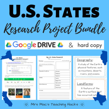
U.S. States Research Project BUNDLE
By Abigail J McClellan
This U.S. States research project includes both a Google version and a hard copy. It is everything you need in order for students to study the U.S. States!! It encourages research skills using National Geographic Kids & various graphic organizers, content-specific vocabulary knowledge, and self-reflection skills! It is easy to use and an awesome project that your students will love! The Google/online version includes over 10 pages of graphic organizers (with examples!), vocabulary terms, and quizzes. The hard copy contains 16 pages of graphic organizers, vocabulary, and grading tools.
- The physical/hard copy of this resource is a group research project intended for small groups to complete and present (in person).
- The Google/online copy of this resource is designed for individual research (in person or distance learning).
This bundle contains the following two products. To see more information about these two specific products and all they entail, you can view them below:
Google Drive U.S. States Research Project
U.S. States Group Research Project
E-Learning / Home Learning / Remote Learning / Distance Learning / COVID-19 / Coronavirus / Paperless
Freebies & Discounts:
Be sure to follow my store by clicking HERE to stay up to date on all my new products, including products that are FREE and on discount!
Comments:
Please leave a comment if you enjoyed this product and found it useful. I really love reading how you are using my products in your classroom :) thank you in advance for taking the time to leave a review!
Volcanoes Adapted Notes and Review
By Sign with me TOD
This product includes vocabulary, notes, and review for students that are learning about volcanoes.
Vocabulary words that are emphasized in this packet include: volcanoes, magma, crater, ash cloud, magma chamber, layers of ash, vent, lava flow, active volcanoes, extinct volcanoes, dormant volcanoes, Earth's crust, tectonic plates, lithosphere, divergent boundaries, transform boundaries, convergent boundaries, Mount St. Helens, and Volcanic Explosivity Index (VEI).
This product on volcanoes covers what a mountain is, how magma comes up to the surface which causes volcanoes to form and erupt, explosive volcanic eruptions compared to effusive volcanic eruptions, students will look at a diagram of a volcano and will label the parts of the volcano using the key, students will learn where volcanoes are found and the three different types of volcanoes - active, extinct, and dormant. Where magma volcanoes form, how pieces of the Earth's surface move slowly, what is the lithosphere and where it is located, where tectonic plates are located in the structure of the Earth, tectonic plates and the three boundaries and how they are different from one another - divergent, transform, and convergent boundaries, students will also learn about Mount St. Helens eruption on May 18th, 1980, students will also learn safety tips and how to prepare for a volcanic eruption, students will analyze two charts: how volcanoes are measured using the Volcanic Explosivity Index (VEI) and some volcanic eruptions in the 21st century, and students will choose a volcano to research and will answer questions after conducting research about a volcano in the packet provided at the end of the product.
Throughout the product, students will answer comprehension questions, true/false questions, multiple choice questions, will label diagrams to ensure comprehension as they are learning about volcanoes.
You may also be interested in the following items:
How Plants Move Materials Adapted Notes and Review
https://www.TeachShare.com/Product/How-Plants-Move-Materials-Adapted-Notes-and-Review-11289814
Forms of Energy Adapted Notes and Review
https://www.TeachShare.com/Product/Forms-of-Energy-Adapted-Notes-and-Review-10626697
Rocks and Minerals Adapted Notes and Review
https://www.TeachShare.com/Product/Rocks-and-Minerals-Adapted-Notes-and-Review-10619690
Traits of Living Things Adapted Notes and Review
https://www.TeachShare.com/Product/Traits-of-Living-Things-Adapted-Notes-and-Review-10497912
Reptiles and Amphibians Adapted Notes and Review
https://www.TeachShare.com/Product/Reptiles-and-Amphibians-Adapted-Notes-and-Review-10438035
The Solar System Adapted Notes and Review
https://www.TeachShare.com/Product/Solar-System-Adapted-Notes-and-Review-10068136
Earthquakes Adapted Notes and Review
https://www.TeachShare.com/Product/Earthquakes-Adapted-Notes-and-Review-10042138
Life Processes of Plants Adapted Notes and Review
https://www.TeachShare.com/Product/Life-Processes-of-Plants-Adapted-Notes-and-Review-Bundle-8403005
Animal and Plant Cells Adapted Notes and Review
https://www.TeachShare.com/Product/Animal-and-Plant-Cells-Adapted-Notes-and-Review-Bundle-8401410
Reacting to the Environment - 5 Senses Adapted Notes and Review
Inherited and Learned Behavior Adapted Notes and Review
Human Body Systems Unit - Bundle
https://www.TeachShare.com/Product/Human-Body-Systems-Unit-Adapted-Notes-and-Review-9397013
Digestive System Vocabulary Review Freebie
https://www.TeachShare.com/Product/Digestive-System-Vocabulary-Adapted-FREEBIE-8411616
Circulatory and Respiratory System Notes and Review
Circulatory and Respiratory System Vocabulary Review Freebie
The Heart Notes and Review
https://www.TeachShare.com/Product/The-Heart-Human-Body-System-Adapted-Notes-and-Review-8409481
Skeletal and Muscular System Notes and Review
If you download this product and enjoy it, please leave a positive review! :)
Flags of Africa Crown & Headband Craft Templates | Africa Coloring Worksheets
By Mrs Wates Teaching Creations
Explore the vibrant diversity of Africa with these engaging Flags of Africa Crown and Headband Templates. This comprehensive pack features templates for all 54 African countries, designed to be easy to cut and assemble. Each template includes a color flag reference, simplified headband designs for quick assembly, and additional templates with writing prompts. Ideal for celebrating cultural events, history lessons, or international days, these templates encourage creativity and learning. Your students can color their own large flag sheet or make a crown, perfect for classroom displays or as a take-home activity. Bring the rich tapestry of African flags to life with this educational resource, suitable for various classroom activities and multicultural projects.
This pack includes the following:
- 54 easy to cut and assemble crown templates,
- 54 side pieces with country name,
- 54 writing prompt templates,
- 54 large coloring in flag templates,
- Color flag for each country.
This pack includes crown templates for the following countries:
- Algeria
- Angola
- Benin
- Botswana
- Burkina Faso
- Burundi
- Cabo Verde
- Cameroon
- Central African Republic
- Chad
- Comoros
- Democratic Republic of the Congo
- Republic of the Congo
- Djibouti
- Egypt
- Equatorial Guinea
- Eritrea
- Eswatini
- Ethiopia
- Gabon
- Gambia
- Ghana
- Guinea
- Guinea-Bissau
- Ivory Coast (Côte d'Ivoire)
- Kenya
- Lesotho
- Liberia
- Libya
- Madagascar
- Malawi
- Mali
- Mauritania
- Mauritius
- Morocco
- Mozambique
- Namibia
- Niger
- Nigeria
- Rwanda
- São Tomé and Príncipe
- Senegal
- Seychelles
- Sierra Leone
- Somalia
- South Africa
- South Sudan
- Sudan
- Tanzania
- Togo
- Tunisia
- Uganda
- Zambia
- Zimbabwe
Click this link to follow my store
❤️ Follow me for Sales and Updates
Sign up for my mailing list
Follow me on Facebook
Follow me on Pinterest
Follow me on Instagram
Follow on Twitter
Your feedback is important to me. If you find this Flags of Africa Crown and Headband Templates pack helpful, please take a moment to leave a rating and review. Your input allows me to continue creating high-quality resources and make improvements where needed. Plus, by rating paid products, you can earn valuable TeachShare credits to use towards future purchases. To leave a review, visit your My Purchases page and click on the provided link. Your support through purchases, ratings, and following my store is greatly appreciated. Thank you, and happy shopping.
Earthquakes Adapted Notes and Review
By Sign with me TOD
This product includes vocabulary, notes, and review for students that are learning about earthquakes.
Vocabulary words that are emphasized in this packet include: earthquakes, temblors, Earth's crust, normal fault, reverse fault, strike-slip fault, layers of earth, seismographs, and Richter magnitude and earthquake effects.
This product on earthquakes covers how Earth's surface changes, the structure of the Earth and how earthquakes happen due to changes/movements in the crust, three different faults - normal, reverse, and strike-slip faults, how the Earth's crust moves, measuring earthquakes with seismographs, how earthquakes strengths are reported, the Richter magnitude scale that shows the effects of earthquakes, a chart showing the strongest earthquakes of the 20th and 21st century and questions are asked based on data from those charts, and students will research one of the earthquakes and locate information about it in the library or on the computer. Throughout the packet, comprehension questions are asked based on the notes to ensure student comprehension and a few multiple choice questions are also asked in this product that relate with earthquakes.
You may also be interested in the following items:
How Plants Move Materials Adapted Notes and Review
https://www.TeachShare.com/Product/How-Plants-Move-Materials-Adapted-Notes-and-Review-11289814
Forms of Energy Adapted Notes and Review
https://www.TeachShare.com/Product/Forms-of-Energy-Adapted-Notes-and-Review-10626697
Rocks and Minerals Adapted Notes and Review
https://www.TeachShare.com/Product/Rocks-and-Minerals-Adapted-Notes-and-Review-10619690
Traits of Living Things Adapted Notes and Review
https://www.TeachShare.com/Product/Traits-of-Living-Things-Adapted-Notes-and-Review-10497912
Reptiles and Amphibians Adapted Notes and Review
https://www.TeachShare.com/Product/Reptiles-and-Amphibians-Adapted-Notes-and-Review-10438035
Volcanoes Adapted Notes and Review:
https://www.TeachShare.com/Product/Volcanoes-Adapted-Notes-and-Review-10047557
Life Processes of Plants Adapted Notes and Review
https://www.TeachShare.com/Product/Life-Processes-of-Plants-Adapted-Notes-and-Review-Bundle-8403005
Animal and Plant Cells Adapted Notes and Review
https://www.TeachShare.com/Product/Animal-and-Plant-Cells-Adapted-Notes-and-Review-Bundle-8401410
Reacting to the Environment - 5 Senses Adapted Notes and Review
Inherited and Learned Behavior Adapted Notes and Review
Human Body Systems Unit - Bundle
https://www.TeachShare.com/Product/Human-Body-Systems-Unit-Adapted-Notes-and-Review-9397013
Digestive System Vocabulary Review Freebie
https://www.TeachShare.com/Product/Digestive-System-Vocabulary-Adapted-FREEBIE-8411616
Circulatory and Respiratory System Notes and Review
Circulatory and Respiratory System Vocabulary Review Freebie
The Heart Notes and Review
https://www.TeachShare.com/Product/The-Heart-Human-Body-System-Adapted-Notes-and-Review-8409481
Skeletal and Muscular System Notes and Review
If you download this product and enjoy it, please leave a positive review! :)
Landforms 2nd Grade | Landform Project | Landform Activities | Landforms Booklet
By Rainbow Lessons
Engage your students and foster a love for geography and exploration with this fun and interactive Landforms Pop-up Booklet tailored specifically for Grades 2 to 5.
This interactive booklet brings mountains, volcanoes, rivers, and more to life with stunning pop-ups and engaging facts.
You’ll get:
▪︎ 12 different landforms pages (blank and traceable facts)
▪︎ Combine landform pages with traceable facts
▪︎ Cover Page
▪︎ Landforms pictures (2 sets)
Includes mountains, volcanoes, plains, rivers, islands, plateaus, hills, valleys, canyons, caves, deserts and waterfalls.
Just print the desired pages and make your own stunning 3D pop-up landforms booklet.
Perfect for curious minds of all ages, this educational booklet combines entertainment with learning, making geography come alive in your hands.
Please check out the preview video for instructions in the Youtube link below:
(I’ve made my booklet with 6 landforms included in set 1.)
Hope you and your students enjoy this resource.
We really appreciate your sparing a few moments to review this resource.
Where is Machu Picchu? Ancient Inca Book Report Template and Digital Lesson
By TaughtOught Homeschooling
Did you know that 60% of Machu Picchu was built underground? Learn more about Peru, Ancient Inca, and Machu Picchu in this comprehensive reading comprehension Google lesson.
This product is so easy to use and has practically no prep:
- Read the book
- Print the 9-page template
- Review the no-prep reading comprehension Google lesson with a built-in reward system (students LOVE this feature!)
- Fill out the book report template based on the reading comprehension review as a group or independent work/homework
The template pages include (and are reviewed in the digital Google lesson):
- book title info
- rating & review
- vocabulary
- facts
- the land (animals & landmarks)
- key information (capital, population, languages, climate, agriculture, natural resources, politicians)
- what I learned
- questions I have
- historic events
- draw a map
Love,
Teacher Bethanie
Sarah Fabiny "Where Is the Amazon?" worksheets
By Peter D
This is a 48-page set of worksheets for the book "Where Is the Amazon?" by Sarah Fabiny. This includes a four-page story test. There are three worksheets for each chapter: * comprehension questions * vocabulary * story analysis Also, there are twenty-two worksheets at the end: * story review * language skills * story reflection * review activity * cause and effect * compare and contrast * illustrations * animals * book design * news report * critical thinking * inferences * summaries * word search * crossword puzzle * story test (four pages) There is also an answer key included at the end of the file. Worksheets for the “Who Was…?” series: * What Was Pearl Harbor? * What Was Pompeii? * What Was the Underground Railroad? * Where Are the Galapagos Islands? * Where Is the Amazon? * Where Is the Grand Canyon? * Who Is Barack Obama? * Who Was Albert Einstein? * Who Was Amelia Earhart? * Who Was Anne Frank? * Who Was Ben Franklin? * Who Was Charles Darwin? * Who Was Eleanor Roosevelt? * Who Was Harriet Tubman? * Who Was Helen Keller? * Who Was Isaac Newton? * Who Was Jackie Robinson? * Who Was Jacques Cousteau? * Who Was John F. Kennedy? * Who Was Leonardo da Vinci? * Who Was Louis Armstrong? * Who Was Marie Curie? * Who Was Nelson Mandela? * Who Was Mark Twain? * Who Was Roald Dahl? * Who Was Rosa Parks? * Who Was Sally Ride? * Who Was Seabiscuit? * Who Was Thomas Alva Edison? * Who Was William Shakespeare? * Who Was Wolfgang Amadeus Mozart? * Who Were The Beatles?
Continents and Oceans Worksheets | Blank World Map with Countries | Geography
By Innovative Classroom Ideas
This set of printable pages on the seven continents is a fantastic way to practice geography. With the help of this continents and oceans worksheet pdf, students will enjoy learning about the seven major continents. Use these maps with kindergarten, first, second, third, fourth, fifth, and sixth grade elementary students as part of a social studies subject, as a stand-alone review, or as additional practice.
These 7 Continents and 5 Oceans worksheets will be a hit with your pupils as they practice labeling the different continents and discover fascinating facts about each one. You only need to print the continents and oceans worksheet to begin teaching kindergarteners, first-graders, second-graders, third-graders, fourth-graders, fifth-graders, and sixth-graders. This no-prep geography lesson will help children learn about Asia, Africa, Australia, North America, Antarctica, South America, and Europe. It is perfect for parents, teachers, and homeschoolers. Now that you have these continents worksheets, you can start learning! The answer key is provided!!
>>>> ⭐ More Similar Activities ⭐ <<<<<
We adore FEEDBACK! You also obtain CREDITS! :
- Access your TeachShare account by logging in.
- Select "My TeachShare" from the drop-down menu.
- Click on "My Purchases."
- Select ratings and provide feedback.
Terms of Use: By purchasing and/or downloading this electronic file, you are allowed to use the product for personal use as you like, but you are not allowed to resell or redistribute.
Follow my store and get all the newest product updates and freebies by clicking the green star ★ above.
♥ Search Key Terms: Continents and oceans, the continents and oceans of the world worksheet, continents and oceans for kids, free continents and oceans for kids, continents and oceans workbook, continents and oceans free course, continents and oceans printables, homeschool continents and oceans, free teaching resources continents and oceans, teaching kids about continents and oceans, classroom continents and oceans resources, homeschool continents and oceans resources, oceans and continents, World map, world maps, world, world geography, map of the world, world map is wrong, world map for kids, world facts, map of world, #world, new world map, free world map, accurate world map, world puzzle, world oceans, fixing the world map, World map, world, blank map, how to draw world map easily, world map drawing, how to draw world map, world maps,European school draw world map, world map drawing easy, world map draw kaise kare, world map flat, world map draw in ias mains exam, how to draw a world map in easy steps, world map quiz, easy world map, how to draw world map in examination, how to dry world map in upsc mains exam,
United States Geography Skills Perfection Speed Center & Game
By The Emergency Sub
US States Geography Game and Center
How many states can you cover before time runs out? In this face-paced Geography game (like the Perfection board game), students must cover as many states with the correct state shape to rack up as many points as possible. The winner with the highest score wins. This game can also be played solo, where students must beat their score.
This game is an excellent review after reviewing the fifty US states. Students will learn to recognize the shapes of states and easily identify them on the map.
This activity is a versatile tool that can be used for early finishers, centers, assessment, buddy groups, or to enhance your lessons on the US States. Its adaptability allows you to use it in various educational settings and for different purposes.
Geography Cardinal Directions Posters and Worksheets
By Jessica Renee Montessori - JRMontessori
Geography Cardinal Directions Posters and Worksheets is the perfect resource to help your lower elementary and Montessori students develop an understanding of the essential concept of cardinal directions. These Montessori-inspired posters make it easy to give a permanent display in the classroom and the accompanying worksheets allows students to participate in the fun!
The posters come in three different versions that correspond with the materials and help you to teach different geography-related concepts such as north, south, east, and west. The first version includes the Montessori map colors, the second shows the Montessori sandpaper globe colors, and the third is a traditional blue and green map for mainstream classrooms. Plus, there are two versions of the worksheet, one with traceable words and one with blank lines. And best of all, this version now covers both the western and eastern hemispheres!
These posters and worksheets are designed especially for lower elementary students who are just beginning to explore the world. Rest assured that you and your students will be able to begin navigating the global terrain with these Geography Cardinal Directions Posters and Worksheets!
✅ Check out the PREVIEW for an in-depth look at this resource!
➩ What's included:
- Teacher Instructions
- Western Hemisphere Posters + Worksheets (24 Pages - PDF)
- Eastern Hemisphere Posters + Worksheets (24 Pages - PDF)
You Might Also Like...
- Montessori Blank Booklets for Kids
- Montessori Work Plan
- Montessori Snake Game Cards
- Montessori Hundred Chart Activity Cards with Colored Beads
⚠️ BUNDLE & SAVE! ⚠️ Save up to 30% on this resource and others by purchasing this item in a comprehensive bundle. Check out the Montessori Store Bundle to save big!
►► Have a question or need help with this resource? Please visit the FAQ Section, submit a help ticket, or ask a question on the Q&A tab!
✨ Keep up with all things Jessica Renee Montessori by completing any of the actions below:
Become a Store Follower on TeachShare
Follow Me on Instagram
Like My Facebook Page
Get TeachShare credits toward future purchases:
After logging in, go to "My Purchases" and find the "Provide Feedback" button beside each product. Leave a fair rating and a comment about the resource, and that's it!
___________________________________
Copyright © JRMontessori
Permission to copy for single classroom use only.
Please purchase additional licenses if you intend to share this product.

American History Us President and USA State Fact Notebook Worksheets
By Tomorrowcomes
President:
Printable black and white notebook worksheets of the 46 United States President. Each page features a picture of the president. The page then focuses on students finding specific general information on an individual president, as well as an area for students to write unique information about the president that is interesting to them.
Specific information the student while look for:
- Nickname
- Born
- Death
- Term in office
- Birthplace
- Political Party
- Vice President
- Spouse
- Number of Children
Sates:
Black and White worksheet on all 50 States. Each sheet asks basic information about individual states for students to fill out. This is a great resource to introduce basic facts of individual states, while students can engage thru drawing the state flower, state bird, state tree, and state shape. A blank worksheet is also included.
Where are The Great Pyramids of Egypt? Book Report Template and Digital Lesson
By TaughtOught Homeschooling
Did you know that the Great Pyramids are one of the world's seven wonders? Learn more about the country of Egypt and The Great Pyramids in this comprehensive reading comprehension Google lesson.
This product is so easy to use and has practically no prep:
- Read the book
- Print the 9-page template
- Review the no-prep reading comprehension Google lesson with a built-in reward system (students LOVE this feature!)
- Fill out the book report template based on the reading comprehension review as a group or independent work/homework
The template pages include (and are reviewed in the digital Google lesson):
- book title info
- rating & review
- vocabulary
- facts
- the land (animals & landmarks)
- key information (capital, population, languages, climate, agriculture, natural resources, politicians)
- what I learned
- questions I have
- historic events
- draw a map
Love,
Teacher Bethanie
Megan Stine "Where Are the Galapagos Islands?" worksheets
By Peter D
This is a 45-page set of worksheets for the book "Where Are the Galapagos Islands?" by Megan Stine. This includes a four-page story test. There are three worksheets for each chapter: * comprehension questions * vocabulary * story analysis Also, there are twenty-one worksheets at the end: * story review * language skills * story reflection * review activity * cause and effect * compare and contrast * illustrations * animals * book design * news report * critical thinking * inferences * summaries * transformation * word search * crossword puzzle * story test (four pages) There is also an answer key included at the end of the file. Worksheets for the “Who Was…?” series: * What Was Pearl Harbor? * What Was Pompeii? * What Was the Underground Railroad? * Where Are the Galapagos Islands? * Where Is the Amazon? * Where Is the Grand Canyon? * Who Is Barack Obama? * Who Was Albert Einstein? * Who Was Amelia Earhart? * Who Was Anne Frank? * Who Was Ben Franklin? * Who Was Charles Darwin? * Who Was Eleanor Roosevelt? * Who Was Harriet Tubman? * Who Was Helen Keller? * Who Was Isaac Newton? * Who Was Jackie Robinson? * Who Was Jacques Cousteau? * Who Was John F. Kennedy? * Who Was King Tut? * Who Was Leonardo da Vinci? * Who Was Louis Armstrong? * Who Was Marie Curie? * Who Was Mark Twain? * Who Was Nelson Mandela? * Who Was Roald Dahl? * Who Was Rosa Parks? * Who Was Sally Ride? * Who Was Seabiscuit? * Who Was Thomas Alva Edison? * Who Was William Shakespeare? * Who Was Wolfgang Amadeus Mozart? * Who Were The Beatles?
World Map with Countries Worksheets | 7 Continents and 5 Oceans Blank Map
By Innovative Classroom Ideas
Kids enjoy studying the world they live in! They will enjoy learning about the seven continents and the corresponding geography with these fun and printable Continents Worksheets. For kindergarteners, first graders, second graders, third graders, fourth graders, and fifth graders, use these continents and oceans worksheets. You may start playing and learning as soon as you print the continents and oceans worksheet PDF.
These 7 continents and 5 oceans worksheets are perfect for parents, teachers, and homeschoolers who want to assist their kids learn about the globe we live in and improve their science skills. For kindergarteners, first-graders, second-graders, third-graders, fourth-graders, and fifth-graders, this pack is ideal. Use these no prep 7 Continents worksheets for science centers, additional practice, at home or at school, or as a component of a continent study. Children will learn about the seven continents that today make up the world in which we live with this bundle. Answers are provided and this pack comes mainly in black and white with a few color pages thrown in.
There are lots of activities in this pack:
- Continent poster in color
- Color in the continents on the world map following the key
- Cut out and paste the labels onto the continents
- Write the names of the seven continents next to the corresponding number
- Color in the continents using the key
- Unscramble the names of the continents
- One page for each of the seven continents with facts that include the hemisphere the continent is in, the oceans that surround it, and the amount of countries that are in that continent
- Write the names of the continents in alphabetical order
- Continent word search
>>>> ⭐ More Similar Activities ⭐ <<<<<
We adore FEEDBACK! You also obtain CREDITS! :
- Access your TeachShare account by logging in.
- Select "My TeachShare" from the drop-down menu.
- Click on "My Purchases."
- Select ratings and provide feedback.
Terms of Use: By purchasing and/or downloading this electronic file, you are allowed to use the product for personal use as you like, but you are not allowed to resell or redistribute.
Follow my store and get all the newest product updates and freebies by clicking the green star ★ above.
♥ Search Key Terms: World map, world maps, world, world geography, map of the world, world map is wrong, world map for kids, world facts, map of world, #world, new world map, free world map, accurate world map, world puzzle, world oceans, fixing the world map, World map, world,blank map, how to draw world map easily, world map drawing, how to draw world map, world maps,European school draw world map, world map drawing easy, world map draw kaise kare, world map flat, world map draw in ias mains exam, how to draw a world map in easy steps, world map quiz, easy world map, how to draw world map in examination, how to dry world map in upsc mains exam, Continents and oceans, the continents and oceans of the world worksheet, continents and oceans for kids, continents and oceans for kids, continents and oceans workbook, continents and oceans free course, continents and oceans printables, homeschool continents and oceans, free teaching resources continents and oceans, teaching kids about continents and oceans, classroom continents and oceans resources, homeschool continents and oceans resources, oceans and continents
Chinese Traditions: Editable Worksheets, Activities & Quizzes for Kids
By The Kidz Lab
Introduce your students to the rich and fascinating world of Chinese Traditions with this engaging, fully editable resource! Designed for middle school and high school learners, this packet provides a comprehensive overview of key cultural practices, values, holidays, philosophies, and their historical significance. Through interactive worksheets, quizzes, and class projects, students will explore one of the world’s oldest and most influential cultures.
What's Included: ✅ Editable short-answer worksheets and multiple-choice questions ✅ Fill-in-the-blank exercises to reinforce understanding ✅ Thought-provoking class discussion prompts and project ideas ✅ Full answer keys included for quick and easy grading ✅ Organized sections on Chinese traditions, celebrations, philosophies, and daily life practices
Topics Covered:
- Traditional Chinese festivals (Lunar New Year, Mid-Autumn Festival, Dragon Boat Festival)
- Key philosophies (Confucianism, Taoism, Buddhism) and their cultural impact
- Family traditions and the importance of filial piety
- Chinese art, music, calligraphy, and martial arts
- How traditions continue to influence modern Chinese society
Skills Developed: ✔️ Cultural awareness and global citizenship ✔️ Critical thinking and historical analysis ✔️ Research and creative presentation skills ✔️ Understanding cultural continuity and change over time
Why You'll Love It:
- Fully editable to adjust for different grade levels and classroom needs
- Great for World History, Social Studies, Cultural Studies, or Global Education units
- Can be used for individual assignments, group activities, class debates, or cultural projects
- Encourages students to make cross-cultural comparisons and understand global diversity
- Suitable for Grades 6–12
File Format:
- PDF version for immediate use
- Editable Word document version for customization
- Printer-friendly and digital-ready!
Usage Ideas:
- Lesson supplements for Chinese history or global studies units
- Homework or enrichment assignments
- Sub plans or independent study activities
- Interactive bulletin boards or cultural appreciation days
Chinese Culture, Chinese Traditions Worksheets, World History Activities, Social Studies Lessons, Cultural Studies Middle School, Global Citizenship, Lunar New Year Activities, Chinese Philosophy Education, Asian Culture Unit, Multicultural Studies, China History Worksheets, Editable Cultural Worksheets, Middle School Social Studies, High School World History, Global Education Resources.
Jim O'Connor "Where Is the Grand Canyon?" worksheets
By Peter D
This is a 45-page set of worksheets for the book "Where Is the Grand Canyon?" by Jim O'Connor. This includes a four-page story test. There are three worksheets for each chapter: * comprehension questions * vocabulary * story analysis Also, there are twenty worksheets at the end: * story review * language skills * story reflection * review activity * cause and effect * compare and contrast * illustrations * animals * book design * news report * critical thinking * inferences * summaries * word search * crossword puzzle * story test (four pages) There is also an answer key included at the end of the file. Worksheets for the “Who Was…?” series: * What Was Pearl Harbor? * What Was Pompeii? * What Was the Underground Railroad? * Where Are the Galapagos Islands? * Where Is the Amazon? * Where Is the Grand Canyon? * Who Is Barack Obama? * Who Was Albert Einstein? * Who Was Amelia Earhart? * Who Was Anne Frank? * Who Was Ben Franklin? * Who Was Charles Darwin? * Who Was Eleanor Roosevelt? * Who Was Harriet Tubman? * Who Was Helen Keller? * Who Was Isaac Newton? * Who Was Jackie Robinson? * Who Was Jacques Cousteau? * Who Was John F. Kennedy? * Who Was King Tut? * Who Was Leonardo da Vinci? * Who Was Louis Armstrong? * Who Was Marie Curie? * Who Was Mark Twain? * Who Was Nelson Mandela? * Who Was Roald Dahl? * Who Was Rosa Parks? * Who Was Sally Ride? * Who Was Seabiscuit? * Who Was Thomas Alva Edison? * Who Was William Shakespeare? * Who Was Wolfgang Amadeus Mozart? * Who Were The Beatles?
Where is the Amazon River? Book Report Template & Reading Comprehension Lesson
By TaughtOught Homeschooling
Did you know that between 65 and 145 million years ago, the Amazon River flowed toward the Pacific Ocean, in the opposite direction it flows today? Learn more about the Amazon River and the land it flows on in this comprehensive reading comprehension Google lesson.
This product is so easy to use and has practically no prep:
- Read the book
- Print the 9-page template
- Review the no-prep reading comprehension Google lesson with a built-in reward system (students LOVE this feature!)
- Fill out the book report template based on the reading comprehension review as a group or independent work/homework
The template pages include (and are reviewed in the digital Google lesson):
- book title info
- rating & review
- vocabulary
- facts
- the land (animals & landmarks)
- key information (capital, population, languages, climate, agriculture, natural resources, politicians)
- what I learned
- questions I have
- historic events
- draw a map
Love,
Teacher Bethanie
Nico Medina "Where Is Mount Everest?" worksheets
By Peter D
This is a 47-page set of worksheets for the book "Where Is Mount Everest?" by Nico Medina. This includes a four-page story test. There are three worksheets for each chapter: * comprehension questions * vocabulary * story analysis Also, there are twenty-three worksheets at the end: * story review * language skills * story reflection * review activity * cause and effect * compare and contrast * illustrations * book design * news report * critical thinking * inferences * summaries * word search * crossword puzzle * story test (four pages) There is also an answer key included at the end of the file. Worksheets for the “Who Was…?” series: * What Was Pearl Harbor? * What Was Pompeii? * What Was the Underground Railroad? * Where Are the Galapagos Islands? * Where Is the Amazon? * Where Is the Grand Canyon? * Where Is Mount Everest? * Who Is Barack Obama? * Who Was Albert Einstein? * Who Was Amelia Earhart? * Who Was Anne Frank? * Who Was Ben Franklin? * Who Was Charles Darwin? * Who Was Eleanor Roosevelt? * Who Was Harriet Tubman? * Who Was Helen Keller? * Who Was Isaac Newton? * Who Was Jackie Robinson? * Who Was Jacques Cousteau? * Who Was John F. Kennedy? * Who Was Leonardo da Vinci? * Who Was Louis Armstrong? * Who Was Marie Curie? * Who Was Nelson Mandela? * Who Was Mark Twain? * Who Was Roald Dahl? * Who Was Rosa Parks? * Who Was Sally Ride? * Who Was Seabiscuit? * Who Was Thomas Alva Edison? * Who Was William Shakespeare? * Who Was Wolfgang Amadeus Mozart? * Who Were The Beatles?
Non-Fiction Reading Comprehension Book Report Template | Where is Antarctica?
By TaughtOught Homeschooling
Did you know that Antarctica contains about 60% of the world's fresh water? If it all melted, it would raise the sea level by about 200 feet! Learn more about Antarctica in this comprehensive reading comprehension Google lesson.
This product is so easy to use and has practically no prep:
- Read the book
- Print the 9-page template
- Review the no-prep reading comprehension Google lesson with a built-in reward system (students LOVE this feature!)
- Fill out the book report template based on the reading comprehension review as a group or independent work/homework
The template pages include (and are reviewed in the digital Google lesson):
- book title info
- rating & review
- vocabulary
- facts
- the land (animals & landmarks)
- key information (capital, population, languages, climate, agriculture, natural resources, politicians)
- what I learned
- questions I have
- historic events
- draw a map
Love,
Teacher Bethanie