Geography PowerPoint Presentations
South America Basic Facts Notes
By TxMAP Teacher
This product is notes over the Basic Facts of South America. It includes topics such as largest and smallest country, largest cities, geographical extremes, regional facts, and regional landmarks. The notes and fill in the blanks are in PDF form. A link to a google slides that you can make a copy of is included at the end of the notes section.
Geography, Map Projections: Which Map Would You Use? Google Slide + Powerpoint
By Geography & Math Made Easy
Teaching map projections can be challenging. This lesson is an easy way to give students the foundation they need to understand what map projections are and how each has its own level of accuracies and distortions based on the size and shape of land masses and measurement/distance between points. This works very well with my students and is a fund group cooperative activity that requires higher-level thinking skills and or helps students develop higher-level thinking skills by analyzing various map projections, and determining their accuracies and distortions.
LESSON: MAP PROJECTIONS: WHICH ONE WOULD YOU USE?
GRADE LEVEL: 7-12th
TIME FRAME: 90-120 MINUTES (TWO 60-MINUTE CLASS PERIODS)
TYPE OF ACTIVITY: GROUP COOPERATION ACTIVITY
NOTE: ADJUST MARGINS UNDER PAGE SETUP BEFORE PRINTING or SCALE TO FIT TO AVOID GRAPHICS FROM BEING CUT OFF.
OBJECTIVE:
- The learner will familiarize his/herself with the following map projections: Robinson Projections, Mercator Projections, Goode Projection, & Hammer Projection
- The learner will understand theaccuracies and distortions of flat map projections.
- The learner will understand the three variables of map projections: Shape, size &
distance. - The learner will investigate and explore various map projections to determine their accuracies and distortions.
- The learner will be able to determine what map projections can be used for accuracies of size, shape & distance.
MATERIALS:
- Presentation: Google slide format & PowerPoint presentation (included in zip file).
- Comparison Chart Listening Chart (1 per student)
- Activity Instructional Sheet: Map It! (1 per group)
- Internet connections to obtain a copy of map projections. (For each group)
- Printer to be able to print the map projection.
- Poster boards or butcher paper are cut into the size of poster boards. (One per group)
- Rubric: Map It Group Presentation
- Provide students with glue, markers, crayons, colored pencils, rulers, and scissors.
PREPARATION:
- Review the presentation and be prepared to discuss the accuracies and distortions of the maps presented.
- Make a copy of the listening guide for each student.
- Have students bring posterboards for group assignments or cut butcher paper into
poster board size pieces. - Make a copy of the Activity Instructional Sheet: Map It! 1 per group.
- Make sure your students will have access to the internet to find a map projection
to examine and a printer that will allow them to print off the map projection. - Print a rubric for each group so they know the requirements.
CLASSROOM SETUP:
- A desk and or table will be set up for students to work in teams of two’s, three’s, or with whatever the instructor feels comfortable.
INTRODUCTION: (10 minutes)
- PowerPoint Presentation or Google Slide Show (This is the same presentation)
- The PowerPoint presentation is included in the zip file.
- GOOGLE DOC SLIDE SHOW -- will receive with the purchase
PROCEDURE: (Group Reading Activity—30 minutes)
Divide the class into groups. Provide each group with the Instruction sheet: Map It! As well as a rubric, poster board, crayons, colored pencils, markers, glue, a ruler and scissors. Explain the instructions to the class based on the Instruction Sheet: Map It. Review what the group needs to present during their group presentation using the grading rubric.
CLOSURE / EVALUATION: (20-30 minutes)
Students will present as a group their findings regarding their map projection.
VIDEOS FOR REVIEW OF CONTENT:
Will receive it with the purchase of the lesson.
(Disclaimer: As time passes, some of these videos may be dropped from the sites, which is beyond the author’s control. Therefore, the author has included a wide range of videos for you to choose from in the case this occurs. If a video is removed from a site, this should not reflect the lesson score provided on TeachShare as the author has no control over whether the site allows the video to remain on their site. Simply, choose another video provided or send the author a question asking for help finding another video. TPT asks the buyer to refrain from scoring until an attempt is made to contact the author and work out issues such as these.)
Disclaimer: One purchase is good for one teacher's usage. For additional teachers to use this product, please purchase additional licenses at a discounted rate. This product is under copyright of Geography & Math Made Easy.
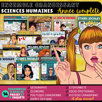
(FR) ÉTUDES SOCIALES - ANNÉE COMPLÈTE (6e ANNÉE)
By French Made Fun!
Vous souhaitez intégrer l’apprentissage par projet et par inquisition dans votre classe, tout en abordant du matériel d’études sociales ? Cet ensemble comprend toutes les ressources de ma boutique qui permettront à vos élèves d'explorer les cartes, la politique, l'histoire, l'économie, la citoyenneté, l'environnement et leur apprentissage social et émotionnel.
J'enseigne avec une approche transdisciplinaire et j'aborde mes projets et activités sous plusieurs angles pour que vos élèves puissent lire, écrire, rechercher, s'amuser et créer des projets individuellement et en petits groupes qui vous épateront !
Ce bundle comprend les 14 ressources suivantes :
- La position géographique (71 pages): A detailed look at cartography, geography and the history of mapping.
- Règles, droits et démocratie canadienne (10 pages): A detailed look at democracy, rules, voting and the political system in Canada.
- Plateformes et politique canadienne (24 pages): Lead an election in your classroom with this project-based approach!
- Brochure touristique (30 pages): Canadian Provinces research project.
- Les secteurs industriels (20 pages + kahoot link): The Canadian Industrial sectors are covered and a link to a Kahoot. A surveying project ties social studies outcomes in with math outcomes with a 14 page student work-book.
- Les autochtones au Canada (50+ pages!): A 2-week long unit on Aboriginals in Canada (my favorite document in my TeachShare store - by far!)
- Symboles et identité (60+ pages!): A 2-week long unit on Canadian symbolism, identity & patriotism
- Oh Canada! (10 pages): A cross-curricular writing, reading and researching activity getting students to rewrite the National Anthem.
- La journée du chandail rose (50+ pages): A unit on bullying.
- Recherche sur les premiers ministres canadiens (23 pages): A small research project on Canadian prime ministers.
- Dans l'oeil du dragon (44 pages): A project-based unit on designing an invention and showing it to a panel of dragons!
- BurgerLove! (60 pages): A project-based look at food waste and the Canadian economy.
- Le jour du souvenir (45 pages): An in-depth look at the history of war and peace.
Like what you see but want to see more? Send me a message to request specific lessons and activities & Subscribe to my TeachShare Store to stay in the loop!
Take care of each other and HAVE FUN!
♡ Mme. Kaitlyn

By TxMAP Teacher
This is a bundle of 10 products related to England's Colonization of America.
Geography & Government Types: Hitler's Olympics of 1936 Propaganda (PowerPoint)
By Geography & Math Made Easy
Hitler used the 1936 Olympics for government propaganda purposes.
The PowerPoint uses posters created by the Germand and focuses on how propaganda techniques were implemented such as using symbols hidden within the images.
Following World War I, Germany was in economic, political, and physical ruins. In 1933, Adolf Hitler became Chancellor and began his quiet quest against anyone who was not Arian. In 1931, Germany was given the option of hosting the 1936 Olympics. Hilter, under his Nazi German totalitarian dictatorship government system, wasn't sure it was a good idea until he was convinced that they could build the largest stadium to be seen at the Olympics and make Germany look as if it was not in ruin. He agreed. The 1936 Olympics were different from the Olympics in the past. It incorporated theatre, high-tech equipment for the games, and wonderful production with a lot of rituals that would continue into the Olympic games after Hitler's Olympics.
Hitler kept the secret of his war against the Jews throughout the two weeks of the Olympics using propaganda to show the world how well Germany was doing; the world, however, had no idea what was in store for Germany and the Jews who lived within its borders.
☑ Check out the preview to see what is included.
Visit our store Geography & Math Made Easy to view other related resources:
Similar Resources & Skills
✧ World Government Lessons
✧ World Economics Lessons
✧ Environmental, Cultural, and Human Issues
.........................................................................................................................................................
CREATE A CUSTOM BUNDLE & SAVE UP TO 20%
Do you need 25 dollars or more of lessons and want to save up to 20%? Just let me know and a customized bundle can be created for you. Learn more about how to ****Create Your Custom Bundle.
.........................................................................................................................................................
Disclaimer:
One purchase is for the use of one teacher. If additional teachers would like to use this product, please purchase additional licenses.
.........................................................................................................................................................
CUSTOMER TIPS
When do I post new products? Throw sales? Be the first to know:
- Click the green star next to my picture to become my newest follower.
Leave A Review and Earn TeachShare Credit to Use on Future Purchases:
- Go under “My TeachShare”, and click on “My Purchases”. Then, click the provide feedback button next to your purchase. Every time you leave feedback on a purchase, TPT gives you credits that you can use to save money on future purchases. I value your feedback as it helps me determine what types of new products I should create for you and other buyers.
........................................................................................................................................................
© Geography & Math Made Easy Resources. Created by Martha Boykin ^ Will Boykin. All rights reserved. Purchase of this product grants the purchaser the right to reproduce pages for classroom use only. If you are not the original purchaser, please download the item from my store before making copies. Copying, editing, selling, redistributing, or posting any part of this product on the internet is strictly forbidden. Violations are subject to the penalties of the Digital Millennium Copyright Act.
.........................................................................................................................................................
Related Topics:
Propaganda, Germany, Olympic 1939, Holocaust, autocracy, democracy, parliamentary democracy and presidential democracy, parliamentary republic, presidential republic, government, government, world goverment, government types, local government, government word search, communism, socialism, democracy, republic, political cartoons, monarchy, constitutional monarchy, absolute monarchy, dictatorship, laws, oligachy. branches of goverment, branches of government, branches of government tree, 3 branches of government, 3 branches of government worksheet, three branches of government, law making, three branches of government project

FULL YEAR/ANNÉE COMPLÈTE BUNDLE 6E ANNÉE | ALL SUBJECTS | 130+ DOCUMENTS
By French Made Fun!
Welcome to the Mega Massive Grade 6 Bundle—your ultimate resource for an entire year's worth of curriculum! This extraordinary bundle includes 131 documents and a staggering 4,000+ pages of content, covering every aspect of Grade 6 Math, French Language Arts, Science, "Transdisciplinary" Units, Cross-Curricular Units, and Project-Based Learning.
Here's what you'll find packed into this 131 document crypt:
Language Arts:
- Complete Genre Studies: Detailed lessons and activities for all genres.
- Mini-Lessons and Workshops: Comprehensive tools for reading and writing instruction.
- Reading and Writing Prompts: Engaging activities to boost literacy skills.
- Excerpts and Writing Pieces: Diverse texts for comprehension and writing practice.
- Modelled Examples and Lesson Plans: Clear guides to support effective teaching.
- Verb and Grammar Units: Thorough resources for mastering French language skills.
- Task and Flash Cards: Interactive tools for grammar and vocabulary practice.
- Posters and Anchor Charts: Essential visual aids for classroom support.
Math:
- Paperless Teaching Slides: Digital slides for all math outcomes, ideal for projection.
- Assessments with Answer Keys: Complete evaluation tools to track student progress.
- Activities and Games: Fun, interactive ways to reinforce math concepts.
- Printable and Digital Games: Versatile resources for various teaching styles.
- Enrichment Material: Advanced content to challenge high-achieving students.
- No-Prep Lessons: Ready-to-go activities that require minimal preparation.
Project-Based Learning:
- Science and Social Studies Projects: Inquiry-based units including Dragons' Den, Sustainable Future projects, Endangered Species studies, Political Platform creation, Haunted House design, and Space Food exploration.
- Health Documents: Comprehensive materials on sexuality, puberty, and other health topics.
- Themed Day Content: Engaging projects for Orange Shirt Day, Pink Shirt Day, Remembrance Day, Earth Day, and a project on O Canada.
Why You'll Love It:
- Massive Content Collection: Over 4,000 pages and 131 documents covering every subject.
- No-Prep, Ready-to-Go: Perfect for busy teachers and easy to leave with a substitute.
- Engaging and Comprehensive: Promotes student independence with project-based and inquiry learning.
- Constantly Growing: New materials added regularly to keep your curriculum up-to-date.
- Versatile and Easy to Use: Printable and digital formats for flexible teaching options.
Get the Mega Massive Grade 6 Bundle today and transform your classroom with this all-encompassing resource, designed to make planning easier and teaching more effective!
** Buying these individually would cost you WELL over $530 USD (that's like OVER $725 CAD). So save yourself time and money and get ready for the next school year! **
Join me on Facebook! I share freebies, keep you up-to-date on sales and deals and welcome your collaboration and feedback.
You can earn TeachShare CREDITS by leaving feedback on any of the products you purchase. You can do so by going to MY PURCHASES your page and clicking on the "Provide Feedback" button. You will earn 1 TeachShare Credit for every dollar you spend!
For goodness sakes, don't forget to have fun!
Mme Kaitlyn

U.S. History Notes Bundle - Beginnings to 1877
By TxMAP Teacher
This bundle is a series of notes over the Eras of U.S. History from the beginnings to 1877. It cover notes from the Age of Exploration through Reconstruction. It includes 16 sets on notes. Each set contains notes with fill in the blanks notes guide.
Presidents & World Leaders Around The World — PowerPoint Game — Geography, Civic
By Geography & Math Made Easy
A Fun PowerPoint Review Game to Engage Your Students!
FOR THE FULL VERSION OF LESSON CLICK HERE
Review the presidents and world leaders throughout the world with this fun Who Am I? PowerPoint game.
This is an engaging President's Day or world government activity on world leaders for geography, civic, and other social studies classrooms. Students get involved in the learning process and will review 15 presidents & leaders (past & present) around the world to understand the place. This can be used as an introductory before or wrap-up lesson following a World Governments unit. Students will recognize world leaders and understand how they played an important part in government and managing their countries — in both positive and negative ways.
(This lesson is easily modified for time restraints. Simply, choose fewer leaders to cover or remove one of the games. Can be modified for middle school and highschool geography and history classrooms.)
PRESIDENTS & LEADERS INCLUDEDsunit. Students will understand and recognize world leaders and how they played an important part in government and managing their countries — both positive and negative ways.
- John F. Kennedy - USA
- Nelson Mandela - South Africa
- Joseph Stalin - Soviet Union
- Adolph Hitler - Germany
- Mao Zedong - China
- Vigdís Finnbogadóttir - Iceland
- Barack Obama - USA
- Mustafa Kemal Atatürk - Turkey
- Leonid Makarovych Kravchuk - Ukraine
- Kim Jong Un - North Korea
- Fidel Castro - Cuba
- Omar Al Bashir - Sudan
- Prathibha Devisingh Patil - India
- Vladimir Putin - Russia
- Rishi Sunak - United Kingdom
LESSON INCLUDES:
- Who Am I? PowerPoint Game
☑ For secondary — middle school and high school students
☑Check out the preview to see what is included.
Visit our store Geography & Math Made Easy to view other related resources.
OTHER RESOURCES YOU MAY LIKE:
✧ Full Version of Presidents and Leaders Around the World
✧ Additional Government-Focused Geography & History Resources
✧ The Ukrainian Crises of 2022: Vladimir vs. Volodymyr
✧ Is Our Government System Fair?
........................................................................................................................................................
CREATE A CUSTOM BUNDLE & SAVE UP TO 20%
Do you need $25 or more of resources from our store and want to save up to 20%? Just let me know and a customized bundle can be created for you. Learn more about how to Create Your Custom Bundle.
.........................................................................................................................................................
DISCLAIMER
One purchase is for the use of one teacher. If additional teachers wish to use this product, please purchase additional licenses.
.........................................................................................................................................................
CUSTOMER TIPS
When do I post new products? Throw sales? Be the first to know:
- Click the green star next to my picture to become my newest follower and be notified of up-to-date information, sales and new resources.
Leave A Review and Earn TeachShare Credit to Use on Future Purchases:
- Go under “My TeachShare”, and click on “My Purchases”. Then, click the provide feedback button next to your purchase. Every time you leave feedback on a purchase, TeachShare gives you credits that you can use to save money on future purchases. I value your feedback as it helps me determine what types of new products I should create for you and other buyers.
........................................................................................................................................................
© Geography & Math Made Easy Resources. Created by Martha Boykin ^ Will Boykin. All rights reserved. Purchase of this product grants the purchaser the right to reproduce pages for classroom use only. If you are not the original purchaser, please download the item from my store before making copies. Copying, editing, selling, redistributing, or posting any part of this product on the Internet is strictly forbidden. Violations are subject to the penalties of the Digital Millennium Copyright Act.
.........................................................................................................................................................
Related Topics:
geography and math made easy, geography, geography activities, geography unit, government, Presidents Day, presidents, world leaders, government, government word search, us government, local government, Canadian government, turkish government, federal governments, government word search, leadership, leadership activities, leadership worksheets, leadership project, middle school geography, high school geography
(FR) ÉTUDES SOCIALES - CARTES ET LA CARTOGRAPHIE (6e ANNÉE)
By French Made Fun!
This 71-page no-prep, no planning document has everything you need to introduce your students to geography, cartography, mapping and navigation - En Français!
This cross-curricular pedagogical document will provide you with a 37-page slide deck, complete with terms, definitions, examples, discussion prompts, images, games and activities. It also includes a 33-page student workbook complete with printable worksheets, activities, partner work, research, a final project as well as answer keys, a final project rubric and success criteria.
My slides are never babyish and are suitable for grades 4 through 7. They are suitable for students "en adaptation scolaire," or as a simple introduction to concepts covered in grades 5-7. I teach grades 5 and 6, and this works wonderfully for us!
The first half of the document is your teachable slide deck. In it, you'll find:
- A "Would you rather" style game as a warm up!
- A reflection question.
- A discussion prompt to illicit prior knowledge.
- An in-depth look at some of the earliest maps, their history, their evolution, their purpose, the material used and the process behind them.
- A look at modern mapping and their multiple uses, multiple purposes and multiple features.
- An explanation of scale and "scaling" a map.
- An in-depth look at grids, reticles and the map network with an emphasis on lines of longitude and latitude, the poles, the equator and the meridian.
- Discussion prompts about the measurement of diameter on our spherical planet.
- A look at the different hemispheres (N, S, E and W.)
- Group discussion prompts about continents and how we read a map of the world.
- Fun Facts about the Canadian provinces.
- Explanations (with visuals!) of different reference maps (physical and topographic).
- A comparison of "good" maps and "bad" maps and the need to be precise and to follow specific criteria when it comes to map-making.
- An activity on labeling Canada.
In addition to the Slide Deck, you'll find a student workbook with loads of printable activities that are excellent to leave with a substitute teacher or to use yourself. It comes with a "cover page" for their binders or duo-tangs. In the student workbook, your students will find:
- A jigsaw activity using Google Maps (group activity)
- A visual aid that highlights different components of a map with examples.
- "Comment utiliser une échelle?" - An activity to practice measuring distance using scale.
- "Comment te rendre chez toi?" - A quick warm-up map-making activity for students to "draw" their way to school.
- "Sais-tu utiliser une échelle?" - A series of distance-measuring activities using the provincial map of your choosing. I've included sheets for all Canadian provinces.
- "Guide touristique de chez vous!" - An activity on finding and measuring distances between their favorite landmarks, amusement parks, shopping and activities in their province.
- "Road Trip! Calculer le temps nécessaire" - An activity for students to calculate the time needed to travel (incorporates algebraic representation and uses the formula T = D/V).
- "Road Trip! Symboles et géographie" - An activity on reading symbols and the universal nature of symbols.
- "Symboles universels: Symboles et la cartographie" - An activity on creating universally-known symbols for universally-known concepts.
- "Système de coordonnées: Comment lire un atlas?" - An activity on using the coordinate system to find locations on a map.
- A world map is provided with a coordinate grid layered through it for these activities.
- Answer keys for all activities here!
- A final project explanation along with success criteria.
- A checklist and rubric are provided for the final project.
This document is part of a larger bundle of social studies/sciences humaines content which can be found here!
While you're at it, join me on Facebook where you can be the first to know about freebies, updated documents, giveaways and more. I'd love to have you!
Don't forget to have fun!
Kaitlyn.
By TxMAP Teacher
This product is notes over the Basic Facts of South Asia. It includes topics such as largest and smallest country, largest cities, geographical extremes, regional facts, and regional landmarks. The notes and fill in the blanks are in PDF form. A link to a google slides that you can make a copy of is included at the end of the notes section.
Geography: Types of Economies - PowerPoint & Keynote Presentation
By Geography & Math Made Easy
Visit our store Geography & Math Made Easy to view other related resources:
.........................................................................................................................................................
What type of economy do we live in? How does it affect our way of life, what we own, where we work, how we obtain resources, and how goods and services are produced? This resource will help your students understand the different types of economies and how each plays a role in cultures around the world.
To Get the FULL VERSION of this lesson, click here.
Understanding economic systems — Traditional economy, market economy, command economy, and mixed economy — can influence the way we live, work, and obtain resources. Grab this Introductory PowerPoint or Keynote introductory presentation with a listening guide to jumpstart your lesson on world economic systems.
WHAT'S INCLUDED;
- Introductory PowerPoint or Keynote Presentation
- Listening Guide (Both versions included)
OBJECTIVES:
- The learner will understand the four main economic systems.
☑ Check out the preview to see what is included.
OTHER LESSON & RESOURCES YOU MIGHT LIKE;
✧ World Economies Resources
✧ World Government Resources
✧ PowerPoint Presentations
Visit our store Geography & Math Made Easy to view other related resources:
.........................................................................................................................................................
Disclaimer:
One purchase is for the use of one teacher. If additional teachers would like to use this product, please purchase additional licenses.
.........................................................................................................................................................
CREATE A CUSTOM BUNDLE & SAVE
Do you need 25 dollars or more of lessons and want to save up to 20%? Just let me know and a customized bundle can be created for you. Learn more about how to Create Your Own Bundle.
.........................................................................................................................................................
CUSTOMER TIPS
When do I post new products? Throw sales? Be the first to know:
- Click the green star next to my picture to become my newest follower.
Leave A Review and Earn TeachShare Credit to Use on Future Purchases:
- Go under “My TeachShare”, and click on “My Purchases”. Then, click the provide feedback button next to your purchase. Every time you leave feedback on a purchase, TPT gives you credits that you can use to save money on future purchases. I value your feedback as it helps me determine what types of new products I should create for you and other buyers.
.........................................................................................................................................................
© Geography & Math Made Easy Resources. Created by Martha Boykin ^ Will Boykin. All rights reserved. Purchase of this product grants the purchaser the right to reproduce pages for classroom use only. If you are not the original purchaser, please download the item from my store before making copies. Copying, editing, selling, redistributing, or posting any part of this product on the internet is strictly forbidden. Violations are subject to the penalties of the Digital Millennium Copyright Act.
.........................................................................................................................................................
Related Topics:
Command economy, market economy, mixed economy, traditional economy, economic systems. types of economies, economics, economics unit, economics project, economic types, world economies, world economy types, types of world economies, free enterprise, free market, capitalism, capitalist economy, PowerPoint
North America Basic Facts Notes
By TxMAP Teacher
This product is notes over the Basic Facts of North America. It includes topics such as largest and smallest country, largest cities, geographical extremes, regional facts, and regional landmarks. The notes and fill in the blanks are in PDF form. A link to a google slides that you can make a copy of is included at the end of the notes section.
NEW! Geography — A Safe Pace to Land Push & Pull Human Migration
By Geography & Math Made Easy
This is a comprehensive lesson on the reasons for migration and how push and pull factors play a part in the process. Students will watch a PowerPoint on Migration and participate in a group reading activity. As a group students will explore a time in history when people migrated based on economic, social, political, environmental, and demographic reasons based on Ravenstein’s 7 Laws of Migration.
OBJECTIVES:
- The learner will understand how migration impacts society.
- The learner will understand how and why people migrate internally and internationally.
- The learner will examine migration throughout history, examining the push and pull factors of migration.
- The learner will become familiar with the five influences of push and pull factors.
- The learner will become familiar with who Ravenstein was and his 7 Laws of Migration.
MATERIALS:
- Introduction Activity: Watch the Human Migration PowerPoint
- Teacher guide to PowerPoint
- A Safe Place to Land Group Reading Activity (Included)
- A Safe Place to Land Comprehension Research Activity Migration Cards. Find a time in history when people migrated based on economic, social, political, environmental and demographic reasons
- Online access for research for each group
- A Safe Place to Land Character Analysis and Peer Teaching (Included)
- A Safe Place to Land Migration Cards (Front and back - Included)
- Ravenstein’s 7 Laws of Migration Chart (Included) + a way to display it for the class
- Timer for peer teaching activity.
PREPARATION:
- A Safe Place to Land Group Reading Activity (suggest one per group member to be used throughout the day with other classes.)
- Cut, glue (front to back), laminate and place in a paper bag cards for the drawing.
- Paper bag for the drawing Comprehension Research Activity
- Print A Safe Place to Land Character Analysis and Peer Teaching, one per group.
- Print Safe Place to Land Migration Cards, enough for one card per student.
- Print off Ravenstein’s 7 Laws of Migration Chart.
INCLUDES:
- Detailed Teacher Instruction
- An Introduction
- The procedure which includes the Reading Activity, Game, and Character Analysis
- Closure activity
☑ Check out the preview to see what is included.
Visit our store Geography & Math Made Easy to view other related resources:
Similar Resources & Skills
✧ Population Issues & Studies
✧ Cultural, Environmental, & Human Issues
✧ Geography Skills & Basics
.........................................................................................................................................................
CREATE A CUSTOM BUNDLE & SAVE UP TO 20%
Do you need 25 dollars or more of lessons and want to save up to 20%? Just let me know and a customized bundle can be created for you. Learn more about how to ****Create Your Custom Bundle.
.........................................................................................................................................................
Disclaimer:
One purchase is for the use of one teacher. If additional teachers would like to use this product, please purchase additional licenses.
.........................................................................................................................................................
CUSTOMER TIPS
When do I post new products? Throw sales? Be the first to know:
- Click the green star next to my picture to become my newest follower.
Leave A Review and Earn TeachShare Credit to Use on Future Purchases:
- Go under “My TeachShare”, and click on “My Purchases”. Then, click the provide feedback button next to your purchase. Every time you leave feedback on a purchase, TPT gives you credits that you can use to save money on future purchases. I value your feedback as it helps me determine what types of new products I should create for you and other buyers.
.........................................................................................................................................................
© Geography & Math Made Easy Resources. Created by Martha Boykin ^ Will Boykin. All rights reserved. Purchase of this product grants the purchaser the right to reproduce pages for classroom use only. If you are not the original purchaser, please download the item from my store before making copies. Copying, editing, selling, redistributing, or posting any part of this product on the internet is strictly forbidden. Violations are subject to the penalties of the Digital Millennium Copyright Act.
.........................................................................................................................................................
Related Topics:
Push and pull. push and pull worksheets, push and pull sort, push and pull factors, push and pull activities, human migration, human immigration, human emigration, immigration, immigration, immigration project, immigration project, immigration project, migration
North Africa and Southwest Asia Basic Facts Notes
By TxMAP Teacher
This product is notes over the Basic Facts of North Africa and Southwest Asia. It includes topics such as largest and smallest country, largest cities, geographical extremes, regional facts, and regional landmarks. The notes and fill in the blanks are in PDF form. A link to a google slides that you can make a copy of is included at the end of the notes section.
Geography, Big Australia Bucket List (PowerPoint + Travel Activity) Cultural Study
By Geography & Math Made Easy
Included: PDF, Word Document, and Powerpoint
A zip file reader will be needed to open the compressed file.
Students will work in teams — this can be done individually as well but will take a little longer regarding time — to take make a bucket list of places they would like to visit in Australia. They will take a journey to those places (through online resources, books and magazines) and will keep a travel journal of all the places they have visited. Students will enjoy working together and discovering interesting facts about Australia—Down Under. It will allow students not only to enjoy Australia but review the geographical themes as well as learn about the culture.
Materials + Preparation:
· PowerPoint: The Big Australian Bucket List
· 10 Journey Cards for Exploration—1 set per team
· Arrange the room where students can work in teams
· Access to the Internet, books, and magazines for research on Australia
· Printer for students to print out, color, or draw locations visited on their journey
· Grading rubric.
Objectives:
· To explore the natural and human features of Australia.
· To investigate how Australia can be represented on a map as states and territories.
· To investigate the geographical location of capital cities and regional centers around
Australia.
· To identify and locate landmarks and physical features of Australia.
Disclaimer:
One purchase is for the use of one teacher. If additional teachers would like to use this product, please purchase additional licenses.
Russia, Central Asia, and the Caucasus Basic Facts Notes
By TxMAP Teacher
This product is notes over the Basic Facts of Russia, Central Asia, and the Caucasus. It includes topics such as largest and smallest country, largest cities, geographical extremes, regional facts, and regional landmarks. The notes and fill in the blanks are in PDF form. A link to a google slides that you can make a copy of is included at the end of the notes section.
Australia Geography —, The Big Australian Introduction PowerPoint Only
By Geography & Math Made Easy
Present The Big Australian Bucket List PowerPoint.
How the PowerPoint Works: The second slide after the introductory slide will have a grid with 9 images. Each image is linked to a separate slide. Allow students/class to choose which photo on the grid to visit first, then second, and so on. Each will have a number from the student to choose to make it easy to decipher. Once the image is clicked, it will take you to a slide within the PowerPoint that will provide information regarding Australia. Once you have visited it, click the back arrow to return to the grid and allow students to choose another image to explore. Continue until all 9 images have been explored.
Note: the lesson says it will take 30 minutes to present but at the most it will take 15 minutes.
For the entire lesson with cooperative activity, click here:
Disclaimer:
One purchase is for the use of one teacher. If additional teachers would like to use this product, please purchase additional licenses.
Australia and Oceania Basic Facts Notes
By TxMAP Teacher
This product is notes over the Basic Facts of Australia and Oceania. It includes topics such as largest and smallest country, largest cities, geographical extremes, regional facts, and regional landmarks. The notes and fill in the blanks are in PDF form. A link to a google slides that you can make a copy of is included at the end of the notes section.
NEW! Let's Map It! Map & Projections (PowerPoint Only) Map Skills
By Geography & Math Made Easy
Students will become familiar with the difference between reference, thematic and projection maps. This PowerPoint will ask student to examine 13 different maps and projections to determine what category each fall into. The answer is given by flying in a smiling face to the correct category. Teachers and students can discuss the reasons that each map falls into the category that it does. This would be used as an introductory presentation.
For the full version of the Let's Map It! lesson, click here.
Disclaimer:
One purchase is for the use of one teacher. If additional teachers would like to use this product, please purchase additional licenses.
By TxMAP Teacher
This product is notes over the Basic Facts of Europe. It includes topics such as largest and smallest country, largest cities, geographical extremes, regional facts, and regional landmarks. The notes and fill in the blanks are in PDF form. A link to a google slides that you can make a copy of is included at the end of the notes section.